
 Continue with onX Maps
 Continue with Facebook


 Intermediate

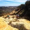
“A singletrack switchback through an s-turn on Burma Fire Road. ”


0.5
Miles0.8
KMSingletrack
 Intermediate
Land Manager: Palos Verdes Peninsula Land Conservancy
 Sullivan-Yedvarts-Cheney-Backbone
22.0 mi 35.4 km • 3,681' Up 1122.1 m Up • 3,681' Down 1121.98 m Down

 Big Topanga Loop
21.5 mi 34.6 km • 3,257' Up 992.63 m Up • 3,254' Down 991.93 m Down
 Casa Viejo Loop
3.7 mi 5.9 km • 811' Up 247.25 m Up • 808' Down 246.25 m Down
Santa M…, CA
Sullivan Canyon to Sullivan Ridge Loop
8.9 mi 14.3 km • 1,440' Up 438.97 m Up • 1,438' Down 438.45 m Down
Santa M…, CA
Topanga Creek Outpost Loop
10.7 mi 17.3 km • 1,382' Up 421.1 m Up • 1,382' Down 421.23 m Down
Zuma Loop
13.2 mi 21.2 km • 2,760' Up 841.17 m Up • 2,757' Down 840.46 m Down


1 Comment