
 Continue with onX Maps
 Sign in with Facebook


 Easy/Intermediate

“A wide, doubletrack fire road frequently used by hikers and other pedestrians. ”


2.4
Miles3.9
KMDoubletrack
 Easy/Intermediate
Land Manager: Palos Verdes Peninsula Land Conservancy
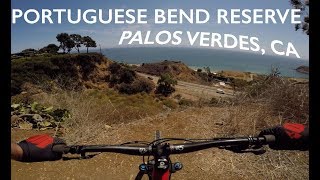
 Portuguese Bend Reserve Loop
7.8 mi 12.6 km • 1,508' Up 459.63 m Up • 1,518' Down 462.69 m Down

 Catalina Island Mountain Biking - Airport - Little Harbor - Avalon
27.9 mi 44.9 km • 2,614' Up 796.69 m Up • 4,186' Down 1275.94 m Down
Avalon, CA
 Backbone Trail: Will Rogers to Temescal Ridge
14.2 mi 22.8 km • 1,953' Up 595.27 m Up • 1,970' Down 600.39 m Down
Sullivan Canyon to Sullivan Ridge Loop
8.9 mi 14.3 km • 1,440' Up 438.97 m Up • 1,438' Down 438.45 m Down
Santa M…, CA
Topanga Creek Outpost Loop
10.7 mi 17.3 km • 1,382' Up 421.1 m Up • 1,382' Down 421.23 m Down
Powder Canyon
6.7 mi 10.8 km • 1,165' Up 355.22 m Up • 1,167' Down 355.65 m Down


1 Comment