Continue with onX Maps
 Sign in with Facebook


Los Angeles
 CA
CA- Los Angeles


Overview
Exploring one of Los Angeles' many parks, open spaces, or surrounding National Forests continues to be one of the best ways to escape the most populous county in the U.S. Ranging from the coastal trails above Malibu stretching out toward Point Mugu State Park, to the city vistas above the Hollywood Hills in Griffith Park and the Griffith Observatory, there are lots of opportunities for easy and moderate hikes.
For the more experienced hiker or exercise fiend, the Santa Monica Mountains to the west or San Gabriel Mountains to the northeast are home to many challenging hikes like up and around Mount Wilson, along the Verdugo Crest Trail, or to the summit of Sandstone Peak. There's no shortage of elevation to gain with expansive, rewarding views along the way.
For hikes with historical or cultural significance, the Hollywood Sign has become a rite of passage, but the M*A*S*H relics at Malibu Creek State Park or ruins at Murphy Ranch are also worth the visit.
Easy hikes:
Intermediate hikes:
Difficult hikes:
Visiting Tips
Camping & Lodging
For drive-up campgrounds, check out the Manker Flats Campground near San Antonio Falls or the Chilao Campground near Big Tujunga Canyon and the Silver Moccasin Trail.
Along the Malibu coastline in the Santa Monica Mountains, you can find established camping in one of these four state parks:
- Leo Carrillo State Park: Hike and Bike ($10/person), Canyon Family ($45/night), Group Walk-In ($225/night)
- Point Mugu State Park: Big Sycamore Canyon Hike/Bike ($10/person), Big Sycamore Canyon Family Camp ($45/night), and much more.
- Malibu Creek State Park: Malibu Creek Family Campground ($45/night), Malibu Creek Group Camp Walk-In ($200/night)
- Topanga State Park: Musch Camp Backcountry Hike-In ($7/person/night and $10/night parking fee)
Food & Drink
Other Activities
Recommended Routes in Los Angeles - 33
MTB Project is built by riders like you. Add Your Recommended Routes


 Difficult
The Luge Loop
7.7 mi 12.4 km • 1,227' Up 373.89 m Up • 1,203' Down 366.69 m Down

 Portola…, CA

 Intermediate
Marshall Canyon
10.4 mi 16.8 km • 1,355' Up 413.03 m Up • 1,356' Down 413.43 m Down
La Verne, CA
 Difficult
El Prieto Loop
8.3 mi 13.4 km • 1,262' Up 384.6 m Up • 1,263' Down 384.89 m Down
La Caña…, CA
 Intermediate
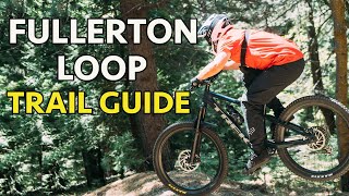
Fullerton Loop
11.2 mi 18.1 km • 669' Up 203.99 m Up • 679' Down 206.81 m Down
 Intermediate
Gabrielino Trail: JPL to the USFS Dam
8.8 mi 14.1 km • 577' Up 175.77 m Up • 578' Down 176.14 m Down
La Caña…, CA
 Intermediate
Lower Monroe Truck Trail
16.1 mi 25.9 km • 2,319' Up 706.97 m Up • 2,319' Down 706.93 m Down
Glendora, CA
 Difficult
Ken Burton Loop
14.8 mi 23.7 km • 2,055' Up 626.5 m Up • 2,058' Down 627.35 m Down

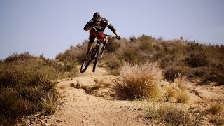
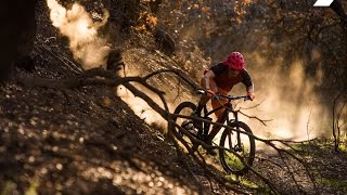
Los Angeles Biking
- 471 Miles 757 Kilometers of Trail
- 33 Recommended Routes
- 57
Easy Trails

- 209
Intermediate Trails

- 40
Difficult Trails

Areas Within Los Angeles
Weather Averages
|
High
|
Low
|
Precip
|
Days w/
|
| J | F | M | A | M | J | J | A | S | O | N | D |
Trails in Los Angeles - 273
MTB Project is built by riders like you. Add Your Trails
|
0.6
mi
1.0
km
#1Telonics
Difficult
Laguna Beach, CA
|
Difficult
|
Laguna Beach, CA |
21
|
|
|
1.8
mi
3.0
km
#2Hummingbird
Difficult
Chatsworth, CA
|
Difficult
|
Chatsworth, CA |
28
|
|
9.1
mi
14.7
km
#3Mt. Wilson Toll Road
 Intermediate/Difficult
Altadena, CA
|
Intermediate/Difficult
|
Altadena, CA |
30
|
|
|
2.6
mi
4.2
km
#4Marshall Canyon Trail
Intermediate
La Verne, CA
|
Intermediate
|
La Verne, CA |
18
|
|
|
2.5
mi
4.1
km
#5Chumash Trail
Difficult
Santa Susana, CA
|
Difficult
|
Santa Susana, CA |
17
|
|
|
0.9
mi
1.5
km
#6Malaga Dunes
Intermediate
Palos Verdes Estates, CA
|
Intermediate
|
Palos Verdes Estates, CA |
16
|
|
2.1
mi
3.4
km
#7Demens Creek Trail
 Easy
Easy
San Antonio Heights, CA
|
Easy
|
San Antonio Heights, CA |
1
|
|
|
1.7
mi
2.7
km
#8Schabarum-Skyline Trail
Intermediate/Difficult
La Habra Heights, CA
|
Intermediate/Difficult
|
La Habra Heights, CA |
1
|
|
|
1.0
mi
1.6
km
#9Happy Flow
Difficult
Moorpark, CA
|
Difficult
|
Moorpark, CA |
1
|
|
1.9
mi
3.1
km
#10Rattlesnake Ridge Trail
 Easy/Intermediate
Whittier, CA
|
Easy/Intermediate
|
Whittier, CA |
1
|
Photos of Los Angeles - 1,516
MTB Project is built by riders like you. Add Your Photos