
 Continue with onX Maps
 Continue with Facebook


 Intermediate/Difficult

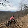
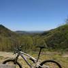
“Climb to 4,800 feet on a ridgeline to the NC/TN border with views, connects to Horse Creek Jeep Trail and beyond. ”


1.9
Miles3.0
KMDoubletrack
 Intermediate/Difficult
Local Club: SORBA - Tri-Cities
Land Manager: USFS - Cherokee National Forest - Nolichuky-Unaka Ranger Station
 Birchfield Lake Lollipop
12.7 mi 20.5 km • 2,358' Up 718.67 m Up • 2,358' Down 718.79 m Down

 Round Knob Loops
19.8 mi 31.8 km • 3,245' Up 989.13 m Up • 3,179' Down 969 m Down
Buffalo Mountain Fire Tower
13.5 mi 21.7 km • 1,944' Up 592.49 m Up • 1,876' Down 571.75 m Down
Hella Climbing aka Gotta Love Rocks
24.7 mi 39.7 km • 3,930' Up 1198.01 m Up • 3,928' Down 1197.32 m Down
 Off-Road Assault on Mt. Mitchell
62.0 mi 99.7 km • 8,895' Up 2711.18 m Up • 8,903' Down 2713.57 m Down
Black M…, NC
Off-Road Assault On Mt. Mitchell
62.0 mi 99.8 km • 8,772' Up 2673.63 m Up • 8,779' Down 2675.82 m Down
Black M…, NC


0 Comments