Dogs Unknown

E-Bikes
Unknown
Description
Although
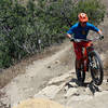
Coal Canyon Trail is part of Chino Hills State Park, it is on the opposite side of Highway 91. Riders must ride along the Santa Ana River
Trail, paralleling noisy Hwy 91, to find the trailhead at the old Coal Canyon highway exit which now acts as a wildlife corridor.
After passing under Hwy 91, the trail begins a meandering climb, eventually ending at OC's "Mini-Moab" and
Leonard Road Trail to Sierra Peak.
I was not able to ride much of the trail last weekend but hope to complete a better report soon. Until then, it was unclear to me whether the trail allows bikes to continue on it after it is shown to end on the Chino Hills State Park map. However, the trail itself continues beyond the end point shown.
Contacts
Shared By:
Phil Reyes

 Continue with onX Maps
 Continue with Facebook


 Intermediate


0 Comments