Dogs Leashed

E-Bikes
Unknown

Parts of the Forks of the River Wildlife Mgmt. is closed periodically in winter for hunting.
Overview
This is the shortest version of the Urban Wilderness loop in Knoxville, TN. This loop gives a taste of the over 30 miles of trails in the system. All trails are only 2-4 miles from downtown Knoxville.
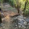
The trails offer something for everyone. There are rock gardens, buff singletrack, paved greenways, and gravel doubletrack.
Need to Know
Ride the trails then head downtown for craft brews and great food.
Be mindful of weather. Rain makes sloppy conditions in the clay soil for a couple of days.
For more information and local rides and maps go to
ambc-sorba.org/
Description
There are several trailheads for this ride. There are many side trails that can be a little confusing, but the signage is pretty good and getting better. There are trail maps posted at all trailheads. Don't be afraid to check out some of the side trails. Most of the side trails are a little to a lot more technical.
This ride starts at Anderson School. From the school, head west on Centeroak Dr. Cross Sevierville Pk (careful), turn right onto
Redwood. Take
Redwood to the top of the hill. Keep going uphill and singletrack starts at the end of the road. About 50 feet in take the right fork onto
Sydney Belle.
Sydney Belle turns left about 200 yards in. Stay left. Continue straight downhill to with
Sinkhole. Stay left. Another 100 feet brings you to the doubletrack ofthe old
Margaret Road. Turn right on
Margaret. Look for
Shadow Run at the bottom of the hill going left.Enjoy flowing
Shadow Run and it's multiple bridges uphill to intersection with
Marge McClean. Right is
Rock Ledge, straight is
View Park, slight left is an unnamed doubletrack straight up the ridge and finally, a hard left connects to Marg McClean Trail. This is the one you want. You have just completed the William Hastie Natural Area portion of the loop.
At the top of the ridge, the Marg McClean Trail intersects with
View Park Drive. Turn right, down the hill. Go about 150 feet and look for the sign and bamboo grove on the left. Enter the
Victor Ashe Trail. The 250' elevation lost in next two miles are some of the most fun you'll have riding the loop.
At the bottom cross a long bridge and follow the trail to intersection with Sevierville Pike. Cross carefully. You just completed the Marie Myers section. Locally this trail is often mistakenly called Marie Myers. Head straight on
Southside Drive to a left at the sign for
Turnbuckle Trail.
You are now entering the Ijams Nature Park (Meades Quarry section). The
Turnbuckle Trail has rocks, bridges, switchbacks and short steep climbs, some along small bluffs. Follow
Turnbuckle through a short uphill with switchbacks. You'll soon cross a bridge that hugs a cliff. There are flowing sections mixed with more technical sections mostly downhill. Experienced riders will love it, beginners may have to walk some sections. Stay to the right until
Turnbuckle makes you enter onto the gravel road, Imerys. In about 100 feet
Turnbuckle goes straight and you'll go left staying on the gravel. Follow the gravel all the way to the Meade's Quarry parking lot. You are now leaving the Ijams Section of the loop.
Go straight across Island Home Pike, then take a right onto the
Will Skelton Greenway. The next mile or so stays on this paved greenway. Look for the sign for the Urban Wilderness South Loop and Auggie's Run.
You are now entering the Forks of the River Wildlife Management Area. Auggie's Run climbs to Intersection with
Bluff Trail. At
Bluff Trail follow the South Loop signs closley. There are very steep and technical sections of Bluff that hug the bluff and the South Loop skirts away from the bluff for a more gentle and fun ride. Follow the South Loop Bluff to it's intersection with
Dozer. Turn left on
Dozer and follow the doubletrack out to Burnett Creek Road. Note that during hunting season that
Bluff Trail and the southern part of
Dozer are the ONLY legal sections of the Forks of the River Wildlife Management Area.
The next section goes through private property. Easements and agreements cover all these trails. Please be respectful of the land owners and their generosity and stay on marked trails. About 100 yards up Burnett Creek Road turn left onto gravel. After a couple hundred yards on the gravel you'll cross Johnson Creek. In another 30 ft. turn rt. onto Lost Chromesome. Watch for the left onto a short section of doubletrack then a quick rt turns to stay on course. Follow Lost Chromesome back to Anderson School.
History & Background
Knoxville's Urban Wilderness came about by way of partnering of The Appalachian Mountain Bike Club, Legacy Parks Foundation, City of Knoxville, Knox County, Tennessee Wildlife Resources Agency and private landowners. The trails pass by old marble quarrys, failed housing developments from the 1982 World's Fair, a wildlife management area managed for hunting and private properties. The junction of the Holston and French Broad Rivers form the Tennessee River next to the greenway. Much of the land was purchased by the Legacy Parks Foundation explicitly to complete the Urban Wilderness Loop.
Some of the trails were old hiking, motorcycle, hunters or access roads. Most of the trails were built by The Appalachian Mountain Bike Club starting in 2007.
Contacts
Shared By:
Randy Conner
with improvements
by Vinnie Connors

 Continue with onX Maps
 Continue with Facebook


 Intermediate

 Easy Rider - Hastie

 Knoxville, TN
 UW Extra Credit Loop
 Trailhead Beer Market Half South Loop


 All Clear


5 Comments