Dogs Unknown

Features
Views
Overview
The steep southern slopes of Monte Grappa (1,776 m) dominate the plain of Veneto. In WW1, the Italian army built lines and trenches near the mountain peaks and a system of dirt roads and mule tracks to connect them with the plains below. This ride is a short loop from the village of Crespano up to Monte Grappa and back, using the best trails.
Need to Know
Parking possible in Crespano. Recommended only in the described direction.
Description
From Crespano (elev. 300m) take the road "Via Madonna del Covolo" uphill, passing the sanctuary "Madonna del Covolo", until its end. Continue your ascent along the old mule track
Mulattiera del Covolo (Part of Sentiero #105). Follow the
Ardosetta Doubletrack (Part of Sentiero #105) upwards and finish your climb to the top of Monte Grappe (elev. 1,776m) via the paved road. Take a break at an impressive WW2 resistance memorial with a beautiful viewpoint.
I recommend a short walk (cycling is prohibited there) to the WW1 memorial at the top. It may be better to secure the bike with a lock.
Cross the eastern slope of Monte Grappa at flowy
Spaurasso Trail and reach the saddle "Croce dei Leibi" (elev. 1,526m) at the rocky
Cresta dei Lebi. The way down to Pian dela Bala (elev. 1,380m) is rideable at
Croce dei Lebi: South, continued by the lower part of
Val Vecia Dirt Road.
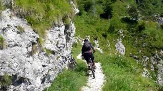
Climb the rocky southern slope at
Boccaor Trail (Part of Sentiero delle Meatte #152), enjoy the dizzying heights and some small tunnels. Continue at
Meatte Trail (Part of Sentiero delle Meatte #152) and turn off into the legendary line of
Sentiero #153. Plunge into the steep abyss on this trail and reach the deep valley of "San Liberale".
Follow
Valle San Liberale (Part of Sentiero #151) to San Liberale (elev. 600m), continue at the paved road "Via San Liberale" toward Sant Andrea / Fietta. Where this road leaves the bottom of the valley and climbs to left, take a dirt road road at your right:
San Liberale - Baita Alpini Connector (elev. 570m).
From its end, take the paved road "Via Solaroli" downward, back to Crespano.
Shared By:
Steffen Hauschild

 Continue with onX Maps
 Sign in with Facebook


 Difficult


0 Comments