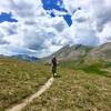
The Monarch Crest is, simply put, one of the best mountain bike rides in the world. This epic 36-mile shuttle begins with jaw-dropping views as you traverse along the vaulted spine of the Rockies, flirting with treeline, on a section of the Continental Divide Trail, aka the
Monarch Crest Trail proper. When you drop off of the divide, the
Silver Creek Trail offers up 4.5 miles of ripping-fast descending as you lose thousands of vertical feet on rocky singletrack. The ride continues seamlessly onto the Rainbow Trail for another ~11 miles of narrow, beautiful singletrack. Whether it's your first or your hundredth ride on the Crest, you're guaranteed a truly spectacular mountain biking experience!
The Monarch Crest is a long point-to-point ride at very high altitudes. NOTE: There is over 3,000 vertical feet of climbing along the way. The elevation profile makes it look like an easy 'downhill shuttle ride,' while in fact, all that high-altitude climbing takes most of the time and energy as the ride progresses. This isn't a beginner ride; it's a very long and very tough intermediate-level ride.
Be prepared for extreme weather including rain, snow and intense sun. Pack plenty of food and water in addition to a few extra layers of clothes.
Self-sufficiency is a must, and adventure is guaranteed.
The nearby town of Salida has a host of post-ride recovery foods and beverages, or make Elevation Beer Co in Poncha Springs your first stop at the end of your ride before rolling the last 5 miles into Salida.
The Monarch Crest - IMBA Epic route starts on the east side of Monarch, about 19 miles up from Poncha Springs. This is the drop-off point for shuttle vehicles. There are shuttle services from Poncha Springs and Salida to the start, or you can shuttle with two cars, leaving one at Monarch Pass and the other in Poncha Springs or Salida.
Ride up the dirt road behind the tram building and climb a bit before finding the start of the
Monarch Crest Trail on the right. The route begins relatively flat and contours through pines. The tread is fairly smooth with a few roots. After a quick climb on a section of doubletrack, stay right again on singletrack. This segment is a bit more technical with roots and a few rocks.
From here the trail is fairly open and has spectacular views of valleys and mountains to the west. Stay right (straight) at intersections with Fooses Creek (access to Colorado Trail), and
Green's Creek Little Cochetopa. Chipeta Peak looms large and beautiful to the east as you pedal up a short steady climb from
Green's Creek.
Above Marshall Pass, the route opens up into doubletrack and descends quickly. Ride past the pit toilet, continuing south. When the road bends right, pedal straight up the hill and then to the right. Look for Monarch Pass Trail on the left.
The route contours again with some short climbs and descents. Most of the time you'll be in the trees with a tread surface that alternates between smooth and rooty.
The Silver Creek intersection will sneak up on you quickly after breaking out into the trees on a quick downhill.
Turn left here for Silver Creek and the Monarch Crest - IMBA Epic route.
The route continues by turning left off Monarch Crest and diving into a series of switchbacks. Be ready for loose, rocky, and a bit rutted trail in places. Losing elevation quickly, you'll roll out into a narrow open valley. The singletrack tightens up as it begins to parallel the Silver Creek.
From here the route contours across the north side of the drainage. The tread surface alternates from dirt and roots to scree. Keep yourself balanced and ready as you cruise down the valley.
After passing a series of beaver ponds in the drainage below the trail, be prepared for the most technical section of the route. Catch a little air off of a rock drop. You'll find yourself landing in a scenic spot with steep cliffs surrounding you.
The last portion of Silver Creek dives into pine and aspen. You'll cross a wooden bridge, then ride through the creek itself for 100 yards until the tree canopy opens up.
From here, continue onto Rainbow Trail (signage changed in 2017 - the new one says "
Silver Creek Trail", which starts to your right after a short section of road.
The trail begins with a few bits of technical terrain, which quickly smooths out to mostly mellow singletrack. It's moderately difficult, save for more than a handful of dips into gulches with very steep, but short climbs back out requiring good bursts of energy to clean.
After about 6.5 miles, you come to a dirt road, which you'll cross to stay on the Rainbow Trail.
The final stretch of the Rainbow Trail is rocky, technical, and dusty in places. While there are a few steep pitches, the conclusion to the descent is rolling and flowing, depositing you onto Highway 285.
Once on the paved Highway 285, which you'll follow it in the downhill direction for about 5 miles back to Poncha Springs.

 Continue with onX Maps
 Continue with Facebook


 Difficult

 4.7 (398)


40 Comments