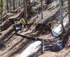
 Race - Aug 25, 2019
Dogs Unknown

E-Bikes
Unknown
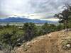
Overview
This is an epic test of endurance, where you ride all of the
Monarch Crest Trail , CT - Segment 15 (Fooses Creek),
Green's Creek,
Starvation Creek,
Silver Creek Trail,
Rainbow Trail #1336: Silver Creek to Mears Junction Hwy 285, and climb North Fooses Creek,
Marshall Pass Road,
Poncha Creek Road, and a section of the
Monarch Crest Trail. All in a day!
Need to Know
If three black diamonds was an available trail rating, this route would have it. The official ride/race has an aid station at the top of Marshall Pass, which you cross three times throughout the day.
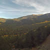
Description
Starting at Monarch Pass before sunrise, ride the
Monarch Crest Trail to the CT - Segment 15 (Fooses Creek) drop in. Descend South Fooses Creek and at the bottom of the singletrack, follow the road around slightly, and head up North Fooses Creek, which progressively gets steeper until it's a loose hike-a-bike back up to the Crest Trail.
Next, continue on
Monarch Crest Trail all the way to the top of
Silver Creek Trail. Descend Silver to the
Rainbow Trail #1336: Silver Creek to Mears Junction Hwy 285. Once at the highway, ride down the shoulder for approximately100 yards and turn left at Mears Junction towards Marshall Pass. Ride up the dirt road for a mile and a half until the beginning of
Marshall Pass Road (200). The next 12 miles is a brutal, never ending pedal up the dirt road until the summit of Marshall Pass.
Then, ride up Starvation Creek 4x4 road past the top, begin descending the 4x4 road and be on the lookout for the
Starvation Creek singletrack off to the right, next to a tree. Descend
Starvation Creek. At the bottom of the singletrack, turn left and climb
Poncha Creek Road back up to Marshall Pass again. Then head backwards up the
Monarch Crest Trail to the top of
Green's Creek. Descend
Green's Creek, continue out CR220 to Hwy 50 back to Poncha Springs.
If you can still walk, you're doing pretty well.
Shared By:
Matt Giaraffa

 Continue with onX Maps
 Continue with Facebook


 Very Difficult


0 Comments