MTB Project Logo

Follow the former "Road of the Cannons", now singletrack, through the grand forest.


Your Rating: Rating Rating Rating Rating Rating      Clear Rating
Your Difficulty:
Your Favorites: Add To-Do · Your List
Zoom in to see details
Map Key

2.9

Miles

4.6

KM

Singletrack

8,194' 2,497 m

High

6,766' 2,062 m

Low

2' 1 m

Up

1,430' 436 m

Down

9%

Avg Grade (5°)

43%

Max Grade (23°)

Dogs Unknown

E-Bikes Unknown

Description

This trail gets its name as it was formerly used to bring heavy artillery up the mountain to the fortifications on the summit. Today, this section has "deteriorated" into a singletrack, making it perfect for mountain biking.

The route starts at the Assietta Road (Unpaved Section) near the Gran Costa summit and is 100% downhill in this direction. Here, you're above the tree line so you've got great views of the mountains on the opposite side of the val Susa (valley) on your way down. At about 2 km (1.2 mi) after 150 m (500 ft) of descent, you'll enter into the forest. Shortly thereafter, the grade levels off somewhat and you can cruise down to the intersection with the Col Blegier forest road.

Of course you can also climb this trail, but it's a difficult climb. It's better to integrate it into the 
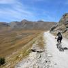
Gran Costa dal Sauze d'Oulx loop so you can catch this segment on the downhill.

Contacts

Shared By:

Lost Justpastnowhere

Trail Ratings

  4.0 from 1 vote

#16791

Overall
  4.0 from 1 vote
5 Star
0%
4 Star
100%
3 Star
0%
2 Star
0%
1 Star
0%
Trail Rankings

#89

in France

#16,791

Overall
1 Views Last Month
60 Since Jan 6, 2018
Difficult Difficult

0%
0%
0%
0%
100%
0%

0 Comments

Current Trail Conditions

Unknown
Add Your Check-In

Check-Ins

Oct 11, 2014
Lost Justpastnowhere
Welcome

Join the Community

Create your FREE account today!
Already have an account? Login to close this notice.

Get Started