Much preferred to descending the
Silver Canyon Road, the Silver Canyon Trail is actually entirely on an old road cut, but after the first half mile or so of descent, you'll forget all about that. It's also substantially less painful (not as steep), and more scenic, than climbing up
Silver Canyon Road. There are some sections that will almost certainly require you to walk, and it is a loooong climb, but the fact that it takes a little longer to get up the same elevation is a big help!
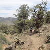
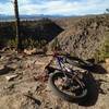
From moto use, the road has turned into singletrack. Some parts are smooth and fast, others are more rocky and technical, pretty much everything is loose, and the scenery is world class. From the crest of the White Mountains, down the ridge and into the narrow north fork of Silver Canyon, this 6.5-mile, 4,000-foot descent is unlikely to disappoint.
This ride can easily be shuttled by dropping one car near the Laws Railroad Museum. Drive the other car down to Big Pine and up to the Ancient Bristlecone Forest. From the Schulman Grove, you can either ride an easy 2.5 miles north up the dirt road to Silver Canyon, or drive it.
Just before the
Silver Canyon Road crosses a saddle and drops off the top of the mountains, a faint doubletrack splits off to the north, joining another faint doubletrack, and passing over a slightly higher saddle before descending to the west. This is the trail.
Alternatively, you can pedal up
Silver Canyon Road, 4,000 feet of elevation in less than five miles to get to the top. A somewhat high clearance vehicle might be needed to get through several creek crossings up 6.7 miles on
Silver Canyon Road from Hwy 6 to where the trail comes out of the canyon to the north. Or, if you're really into suffering, you can start at the bottom and make your climb up a full 6,000 feet of vertical. Either way, just after you cross through the saddle atop the Whites, make a left and head for your descent.

 Continue with onX Maps
 Continue with Facebook


 Difficult


0 Comments