Dogs Leashed

E-Bikes
Unknown

Try to avoid riding here in the summer. Temps can easily reach the high 90's and the trail is very sun-exposed.
Description
Start at the end of Gridley Road - it dead ends at a gate to a private community. Parking is available along the road but is very limited.
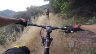
The first part of the trail is very technical and rocky - parts of it are hike-a-bike.
At mile 0.4 you'll hit a fire road. Turn right and start climbing between the avocado fields. Please don't pick any avocados as they're private property.
At mile 0.7 you'll hit the last intersection for a while (until mile 5.8). Turn left and very quickly you'll be up in the mountains, gaining elevation on nice singletrack trails.
Between miles 1.5 and 3 you'll encounter a number of rock gardens. Some of them are quite technical, but all sections are ride-able.
Between miles 3 and 5, the trail becomes much steeper and narrower with a few switchbacks and washed-out sections. That is the most difficult part of the trail by far and you'll want to exercise extra caution here.
From mile 5 and on, the trail levels off and you're pretty much cruising to the top of the Gridley Trail for almost another mile.
At the end of Gridley Trail you'll hit
Nordhoff Ridge Road which extends nearly 15 miles east-west. Turning left (West) will take you to Nordhoff Peak and Pratt Trail. Turning right (East) will take you to Sisar canyon and towards the Topatopa mountains.
The vegetation along the trail is low chaparral brush and small trees. The trail climbs North, so in the summer you'll be exposed to the sun most of the time. There are some creek crossings, but they tend to be wet only during the winter and they're rather shallow.
Contacts
Shared By:
Doron Weinstein

 Continue with onX Maps
 Sign in with Facebook


 Difficult

 4.4 (13)


4 Comments