Dogs Unknown

E-Bikes
Unknown

Closed when wet, although these trails drain well.
Overview
This is North Alabama's version of the trails at the Tsali Recreation Area. You'll receive scenic vistas of Lake Guntersville from the
Tom Bevill Trail and the
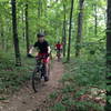
Cutchenmine Trail, and for the most part, these trails are not terribly difficult but feature a few strenuous climbs.
Although these trails were not originally intended for mountain biking and receive no maintenance from a local IMBA chapter, the park's staff and other volunteers have restored them to excellent condition after the April 27, 2011, tornadoes wreaked havoc on them.
There are quite a few climbs on this route but it flows well. The
Cave Trail is the most crooked although a newly re-routed segment of the
Tom Bevill Trail is also more difficult. The
Cutchenmine Trail is mostly easy but has a few steep but brief climbs.
Need to Know
Access at the
Cave Trail start is limited. There are other access points to the park roads along the route that can be utilized, as well. The portion of the ride on the
Tom Bevill Trail between the 7 and 8 mile points was badly damaged during the 2011 tornado outbreak and has been re-routed in such a way as to offer excellent views of the lake.
Lake Guntersville State Park also offers a golf course, cabins, a restaurant, a campground, and a hotel. Boat rentals are also available.
Description
This ride begins on Lodge Drive as you head towards the campground. Park on the side of the road, or park at the trailhead for the Moonshine, Kings Chapel, and
Waterfall trails and ride on the park road to the
Cave Trail.
The
Cave Trail crosses the road here, so you'll want to take the direction going south on the trail. If you go north and pass the cave, you went the wrong way. The trail meanders through the woods and up and down a few "hills" before crossing a closed road. Although it's relatively smooth, it has a few rooty sections and some erosion in a few spots. After crossing the closed road, it gets a little more difficult with a couple of climbs before reaching the
Tom Bevill Trail.
Take a left turn on the
Tom Bevill Trail and continue on up it. There will be a fork after about 0.4 mile. This route assumes you take left fork, which is not as steep, but the right fork is mostly rideable if you want a nice climb. The two forks rejoin each other just before the unmarked intersection with the
Cutchenmine Trail connector.
Turn left onto the connector trail and descend down to AL Highway 227. Cross the highway (be careful!) and head northeast on it (i.e., turn left) a short distance until you see a small pull-out for the
Cutchenmine Trail on the right. The
Cutchenmine Trail is a pleasant rolling ride along Short Creek with a couple of bridges to cross. It is wide, but it has a few somewhat steep climbs which make for fun downhills on the way back. Take the
Cutchenmine Trail all the way out to its end at a creek bed and return back to the
Tom Bevill Trail the way you came.
Turn left when you get back to the
Tom Bevill Trail to continue the loop around Ellenburg Mountain. For the most part, this trail rolls along the mountainside with a couple of steeper climbs, but nothing unmanageable. There are two switchbacks about halfway around the mountain, and you can also get nice views of the lake from this area. The absence of trees (due to the tornado outbreak of 2011) in this area is almost eerie but the lake is beautiful. You'll then pass through a nice thickly forested area which will leave you thinking of Tsali with some fun rolling terrain before you return to the intersection with the
Cave Trail again.
Once back at the
Cave Trail, return the way you came. Alternate options include taking the Spring Trail to the closed road and returning via the
Kings Chapel Trail or the
Terrell Trail, which passes by the old Kings Chapel Cemetery.
History & Background
Lake Guntersville State Park is located along the banks of the Tennessee River in NE Alabama. The park overlooks the majestic 69,000-acre Guntersville Lake and ranges over more than 6,000 acres of natural woodlands. It has 36 miles of multi-use (hiking, biking, and equestrian) trails. Many of the trails pass by remnants of days gone by: old stills, cemeteries, old homesites, and old roads. The park also features a full-service restaurant, a beach complex, outdoor swimming pool, a hotel, cabins, and chalets, and a fishing center along with conference space. The park has recovered from the April 2011 tornadoes.
The 3.4-mile
Tom Bevill Trail features old home sites and excellent views of the lake, and was a 1980 YACC project. The
Cutchenmine Trail is 2.2 miles one way (4.4 out-and back), and follows an old coal mine road along Short Creek. It is a good place to spot herons, wood ducks, and other waterfowl. Eagles are sometimes visible from this trail, depending on the seasons.
Contacts
Shared By:
Zack Butler

 Continue with onX Maps
 Continue with Facebook


 Intermediate

 Lake Guntersville State Park - Figure 8


 Hays Nature Preserve
 Noccalula Fall Evaluation - Alabama MTB 2020
 Blevins Gap Scenic Ride


4 Comments