This route is why we mountain bike! It's challenging but also fun and a great way to see how your skills, fitness, and courage stack up.
I first learned about this route when I began riding in this park with my friend Dewey Oxburger back in the '90s. Dewey was the kind of guy who liked to challenge himself, and wasn't afraid to fall, although it never got worse than some scratches and bruises. Dewey always said that this was the most technical route in the park, and I think it was also his favorite!
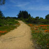
The route begins at the Skeggs Point parking lot and jumps on the very flowy Tafoni Trail. At the first big intersection, go straight across to the Fir Trail, past the vista point, and turn right onto
Resolution Trail.
Resolution is where things begin to get tricky. It starts with some hairpin turns, roots, and rocks as you begin to build up speed. From there, you meet your first patch of sandstone trail where things get really gnarly, although it doesn't go on for too long. After that, things get moving quickly as you continue to head downhill.
Resolution ends at a Y intersection and this is where you meet the
El Corte de Madera Creek Trail. You can really fly down this part of the trail, so let it rip! When you get to the creek, you begin a short climb that will get you warmed up for things to come.
Take a left at the
North Leaf Trail and have fun as you go up and down the side of the hill and over some rocks and roots that have short drops. Keep going until you hit
Methuselah Trail and are able to turn left at a point where the trail goes downhill. This section is a lot of fun and a chance to go fast on some winding singletrack, so let loose when you can.
When you get to the creek at the bottom of the hill, give yourself a break. Drink some water, have an energy bar, and lock out your suspension because you are about to start quite a grind. This section of Methuselah is pretty much all uphill, and it never seems to end. But it's worth the effort when you get to the top!
After you think Methuselah can't go on any longer, and then it continues to go on even further, you'll eventually get to an intersection with several other trails. Take another break at the top, get some water, and be sure to unlock your suspension. Look for the trail immediately to your right, which is called Manzanita. This is the most technical trail in the whole park, and if you love that kind of challenge, this may be the highlight of your ride.
After a couple of quick switchbacks, you'll find yourself back on a good stretch of sandstone rocks. In general, stay right and don't hit your brakes too hard, as that is the best way to get through this section. After a fair bit of downhill on the rocks, you'll face a wall of sandstone that shows up quickly. Do your best to get to the top of that and you'll have gotten through the toughest part of the ride.
Further down the trail, there are more sandstone rocks to traverse, along with some beautiful views out to the ocean on a clear day. These are fun and easier to get through and make you feel like a better rider, especially if you struggled getting up the wall. Manzanita continues with some ups and downs and then lets you out on
Timberview Trail with a clear stretch of downhill as you turn left.
The speed limit here says 15 MPH, but honestly, that is very difficult to stay within as you are on a wide fire road with nothing but downhill and a few bumps ahead of you. Enjoy the ride as this is the last big downhill of the route.
You'll hit
Methuselah Trail again, and you may be tempted to turn left. Don't do that, as it's straight uphill and no fun. Instead, turn right and take that almost to the small parking lot on Skyline. From there, turn left onto
Sierra Morena Trail, which is another fun up and down trail that hugs the side of the mountain.
Turn right at Fir Trail, go past the water tower, down the hill, and you'll end up where you entered the park. Ride back to the parking lot and hope that your legs haven't turned to Jello when you get to your car!

 Continue with onX Maps
 Continue with Facebook


 Difficult

 Scrambled Skeggs


 Purisima Creek Grand Loop


 Bad / Closed


2 Comments