
 Continue with onX Maps
 Continue with Facebook


 Intermediate/Difficult

“After a steep 0.5 mile climb, enjoy four miles of, at times, steep descent followed by an isolated valley. ”


4.2
Miles6.7
KMDoubletrack
 Intermediate/Difficult
Local Club: North Georgia Mountain Bike Association
Land Manager: USFS - Chattahoochee-Oconee National Forest
 Singlespeed Smackdown Deuce 2019
39.7 mi 64.0 km • 5,456' Up 1662.95 m Up • 5,467' Down 1666.36 m Down
 Chatsworth, GA
Mountaintown Creek Loop
Chatsworth, GA
Mountaintown Creek Loop
20.4 mi 32.8 km • 2,935' Up 894.73 m Up • 2,938' Down 895.4 m Down
 Ellijay, GA
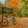
 Amadahy Trail
3.6 mi 5.8 km • 293' Up 89.33 m Up • 286' Down 87.08 m Down
Ellijay, GA
 Cohutta Death March
68.9 mi 110.9 km • 7,609' Up 2319.3 m Up • 7,616' Down 2321.3 m Down
McCaysv…, GA
 Talking Rock Nature Preserve
10.7 mi 17.2 km • 806' Up 245.66 m Up • 806' Down 245.54 m Down
Jasper, GA
4x4 (Long Branch / Green Mountain / Flat Creek)
11.7 mi 18.9 km • 2,006' Up 611.55 m Up • 2,006' Down 611.42 m Down
Blue Ridge, GA


 Minor Issues


1 Comment