
 Continue with onX Maps
 Continue with Facebook


 Difficult

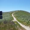
“A steep forest road that ascends/descends to/from the main ridge of the Santa Monica Mountains. ”


3.5
Miles5.6
KMDoubletrack
 Difficult
Land Manager: Santa Monica Mountains National Recreation Area
 Cheeseboro Loop
13.0 mi 20.9 km • 1,514' Up 461.46 m Up • 1,514' Down 461.44 m Down
 Backbone Trail - Puerco Canyon Road Loop
26.0 mi 41.9 km • 4,251' Up 1295.61 m Up • 4,249' Down 1295.16 m Down
 Backbone Trail: Zuma Ridge to Encincal
2.4 mi 3.9 km • 345' Up 105.29 m Up • 685' Down 208.66 m Down
 Dead Cow/Suicide Loop
4.1 mi 6.6 km • 1,126' Up 343.27 m Up • 1,126' Down 343.17 m Down
Oak Park, CA
Los Robles
11.1 mi 17.9 km • 1,603' Up 488.55 m Up • 1,603' Down 488.59 m Down
Casa Co…, CA
 Sullivan Canyon - Westridge Singletrack Loop
11.5 mi 18.6 km • 1,540' Up 469.32 m Up • 1,518' Down 462.78 m Down


0 Comments