
 Continue with onX Maps
 Continue with Facebook


 Intermediate

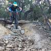
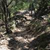
“Singletrack with short, technical rock ledge climbs and descents that is great for laps either AM/PM ”


2.6
Miles4.2
KMSingletrack
 Intermediate
Land Manager: City of Austin - Parks and Recreation
 Lady Bird Lake Trail
10.5 mi 16.8 km • 266' Up 81.11 m Up • 266' Down 81.13 m Down

 Rolling…, TX
 Downtown Austin Tour
6.3 mi 10.2 km • 106' Up 32.17 m Up • 106' Down 32.18 m Down
Austin, TX
 Emma Long Motocross Park: Main Loop
5.7 mi 9.1 km • 529' Up 161.09 m Up • 529' Down 161.13 m Down
Lost Creek, TX
Lakeway Canyonlands & Mt. Lakeway Scenic View
5.8 mi 9.4 km • 799' Up 243.64 m Up • 799' Down 243.55 m Down
Lakeway, TX
 Reimer's Black and Blues
8.1 mi 13.1 km • 444' Up 135.4 m Up • 446' Down 136.01 m Down
Briarcliff, TX
 Pace Bend Park
12.2 mi 19.7 km • 601' Up 183.08 m Up • 600' Down 182.98 m Down


 All Clear


0 Comments