
 Continue with onX Maps
 Continue with Facebook


 Intermediate


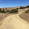
“Take this trail from oak-shaded valley to open ridge top on mostly-graded road. ”


2.0
Miles3.2
KMDoubletrack
 Intermediate
Local Club: Bicycle Trails Council of the East Bay
Land Manager: East Bay Regional Park District (CA)
 Dark Side of the Briones (auto free)
18.9 mi 30.4 km • 2,243' Up 683.54 m Up • 2,519' Down 767.94 m Down
Pinole Ridge Multi-Use Trail
9.7 mi 15.6 km • 1,132' Up 345.1 m Up • 1,131' Down 344.79 m Down

 Tilden Park South Trails
8.2 mi 13.2 km • 1,507' Up 459.2 m Up • 1,507' Down 459.27 m Down
Havey Trail Loop
5.2 mi 8.3 km • 1,044' Up 318.24 m Up • 1,050' Down 319.93 m Down
Big Trees Loop
3.4 mi 5.4 km • 390' Up 118.83 m Up • 390' Down 118.95 m Down
Oakland, CA
Joaquin Down, Up, and Out (auto free)
19.2 mi 30.9 km • 2,126' Up 647.87 m Up • 2,275' Down 693.3 m Down


0 Comments