Dogs Leashed

E-Bikes
Unknown

Georgia DNR regulation prohibits riding before 10:00 AM during spring turkey season (generally during the months of March to May) and fall archery season (generally during the months of September to January).
Overview
This is one of the first mountain bike trails ever built in GA and is everything you could ever want in a trail ride. The Cartecay Loop takes you through wildlife openings, dense forests, some doubletrack forest service road, but primarily singletrack.
There is one very technical downhill, challenging climbs, lots of twists and turns, roots and rocks, the way mountain biking should be. Despite the challenge of the trail, it is worth whatever pain you may endure as you ride down by the river, cross creeks, through fields, get a glimpse of the mountains, hear and see the rushing Cartecay River, and work your way around the loop.
Need to Know
This property is managed by the DNR Wildlife Management Division. Their primary purpose is for wildlife and preserving their habitat. Signage is minimal to nonexistent, bring a map if you are unfamiliar, but it is difficult to get lost as all trails lead back to the parking area. The trail is well maintained by the local bike club, but not manicured. Trail is very challenging, but also very rewarding, you'll not be disappointed. It will challenge you to become a better mountain biker.
Description
From the parking area, pass by the closed gate and follow the service road a short distance until you reach the fork in the road. Stay to the left and proceed up the hill. After the first small incline, the road will have a singletrack fork off to the right, don't go there, stay to the left on the service road and continue up the hill.
At the top of the hill you'll have a real nice view of the mountains and be able to get some speed through the wildlife opening (big, long, open field). Continue straight ahead and you'll enter the woods for about a mile on some rooty and twisty singletrack before coming to the very technical downhill.
The downhill is steep, extremely technical, and consists of lots of roots and rocks. For the expert rider, this downhill is the best part of the loop. For the intermediate rider, this is where you come to be an expert. For all others, you may want to walk your bike down this hill, you'll know when you get there.
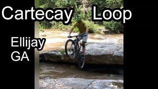
Once at the bottom, take a step off the trail and you are at one of the most beautiful spots on the Cartecay River, great photo area. The trail continues along the river with no real contour in mind and just kinda goes wherever they felt like putting it 40 something years ago, and it is awesome. After the 3rd creek crossing, you'll have to climb your way back up from the river, and don't feel bad if you have to walk parts of it or most of it, it is a beast.
When you are almost at the top of the climb, you'll enter a very dense, young pine forest for a short distance and then the trail will open back up to a singletrack on old forest service road. About 1/4 mile after coming out of the dense pine forest on what used to be a service road, the Cartecay Loop takes a sharp hairpin turn to the left. If you go straight, you go back to the parking lot to complete the
River Loop, don't do that.
Once you make the hairpin turn to the left, there is an awesome section of twisty singletrack that is probably the most enjoyable section and your speed will be dictated by your skill level. Once you reach the service road, take a left down the hill and find your top speed, but avoid the big roots and the holes.
This will bring you through the woods and into the second wildlife opening (big, long field) that may or may not be mowed, just follow the trail to the other end and look for deer. You'll exit the wildlife opening on a service road and go about 1/8 of a mile and the road will turn to the right.
To your left (or actually straight ahead) the Cartecay Loop continues down the steep singeltrack hill with all the little humps and takes you down by the river. Travel alongside the river for a short distance with some fairly sharp ups and downs, and then it is time to climb back out. The climb is long and goes on forever, but once at the top it is a relaxing ride with another small climb before you merge back on the service road which takes you all the way back to the parking area.
History & Background
This is believed to be the first mountain bike trail ever built in GA on 2300 acres of DNR property that is leased from GA Power.
Contacts
Shared By:
Larry Vorpahl

 Continue with onX Maps
 Sign in with Facebook


 Difficult

 Stanley Gap Ultra Loop

 Blue Ridge, GA
 Bear Creek Tour


0 Comments