Dogs Unknown

E-Bikes
Unknown
Overview
This is a good loop if you're in the area and only have an hour to ride. The loop takes you across a couple of old historical rail road grades and through long stretches of towering hemlocks. The trails themselves are not too challenging (but don't let the rail grade description fool you, it is not a rail trail), although it can be wet so be prepared to get your feet wet. The main use of the area is cross country skiing, so no one has dealt with the drainage issues since they are not an issue in the winter. All in all, this is a good route if you are trying to introduce a friend to mountain biking who has some biking skills.
Need to Know
The area is pretty remote and there is spotty cell service so be prepared for anything.
Description
Starting from the Heart's Content Recreation Area Trailhead, Take the middle trail out of the parking lot. (The left is a short cut to the
Tanbark Trail and the right is a hiking only interpretive loop). This Trail is called
Tom's Run Trail, although you won't see that name until the first intersection. The trail at this point alternates between rooty singletrack and some grave and bridges and drops down hill for a while. After a couple of slick bridges (be careful), you'll come to a 4-way intersection. Take a right onto
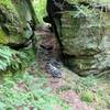
Tanbark Trail and roll through some kind of challenging flood plain trail. There are some cool rock features but also some large puddles if it's been a wet year.
The Trail crosses a bridge and begins to climb out of the flood plain and through some different forest classes. The first part is a bit of a grunt. Eventually, you'll climb up to an intersection with
Ironwood Trail which is an old rail grade. Take a left onto
Ironwood Trail and follow the rail grade for a while. If you notice that the grade goes through a sunken section, look for alternate trails on either side as there is a good chance that the grade becomes swampy when it can't drain.
After a distance, the trail will intersect with
Tom's Run Trail again, turn right and continue down another rail grade. Be sure to check out the house-sized rocks that line the trail for a while after the intersection. The trail will gradually change direction and head uphill for a long ways. Keep an eye out for a left hand turn marked with white diamond blazes. This will be where the loop rejoins
Tanbark Trail.
Turn left and climb out of the valley bottom. There are a few short steep sections, but for the most part the trail isn't too steep. The forest again changes from hemlock stream valley to mixed hardwoods, including the remnants of Chestnut stumps that were cut over a hundred years ago. Chestnut was prized for its size, strength and rot resistance, and the stumps, at 4-5 feet in diameter, are a testament to that.
When you crest the ridge, the trail will start winding downhill back to the original section of
Tom's Run Trail. Turn right and climb out on the first section of the loop back to the parking lot.
History & Background
If you have time to kill, hike the interpretive trail at the parking lot. There are several 400 year old hemlocks as well as some of the largest hickory and beech trees you'll see anywhere. This area was part of a donation from a timber company to the USFS in 1922 and is one of the few uncut tracts of land in the East.
Contacts
Shared By:
Frank Maguire

 Continue with onX Maps
 Continue with Facebook


 Intermediate

 Tanbark Trail

 Rocky Gap ATV trail

 Big Loop


0 Comments