
 Continue with onX Maps
 Continue with Facebook


 Difficult


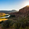
“A rim trail in the southwestern corner of Rabbit Valley. ”


6.0
Miles9.7
KMSingletrack
 Difficult
Local Club: Colorado Plateau Mountain Bike Trail Association
Land Manager: BLM Utah - Moab Field Office
 Zion Curtain
17.9 mi 28.8 km • 1,676' Up 510.87 m Up • 1,677' Down 511.07 m Down
 Rabbit Valley Holy Grail
46.3 mi 74.6 km • 4,057' Up 1236.65 m Up • 4,114' Down 1253.8 m Down
 Rustler's
3.9 mi 6.2 km • 281' Up 85.7 m Up • 325' Down 99.15 m Down
Loma, CO
 Kokopelli Trail
143.4 mi 230.9 km • 13,447' Up 4098.75 m Up • 13,912' Down 4240.25 m Down
Loma, CO
Kokopelli Loops - Mary's, Horsethief, Steve's, and Wranglers
18.7 mi 30.1 km • 1,568' Up 478.03 m Up • 1,565' Down 476.9 m Down
Loma, CO
Tough Enough
37.2 mi 59.9 km • 4,011' Up 1222.69 m Up • 4,018' Down 1224.74 m Down


1 Comment