The Kokopelli trail travels a scenic and circuitous route through the desert from Loma, Colorado to Moab, Utah. It's about 150 miles of mountain biking on terrain varying from technical singletrack to pavement, but the majority of the trail is on old jeep roads.
If you're in Moab want to see what the Kokopelli Trail is all about, go for Segment 5: Fisher Valley to Castle Valley Road.
Segment 1 - Loma Boat Launch to Rabbit Valley, 21 miles - Singletrack along
Mary's Loop and the river rim, then jeep roads to Rabbit Valley.
Segment 2 - Rabbit Valley to Cisco Landing, 34 miles - Mainly old jeep roads with a short section of pavement at the end.
Segment 3 - Cisco Landing to Dewey Bridge, 20 miles - A bit of pavement followed by singletrack. Crosses UT-128 and climbs 1000' on sandy jeep roads, then descends to Dewey Bridge.
Segment 4 - Dewey Bridge to Fisher Valley, 18 miles - Climbs 2500' on bumpy gravel, then drops down a 4WD road into the Fisher Valley and Onion Creek Road.
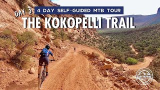
Segment 5 - Fisher Valley to Castle Valley Road, 25 miles - Climbs 3500' on jeep roads to Fisher Mesa in the La Sal Mountains, then drops 2000' down pavement.
Segment 6 - Castle Valley Road to Moab, 27 miles - Climbs almost 2000' on pavement to Mason Draw, then drops 4000' down singletrack and jeep roads into Moab.
The Kokopelli trail is pretty well marked with brown carsonite signposts, but a map, GPS, or the MTB Project mobile app will come in handy at the intersections.
Start as for
Mary's Loop but continue all the way out to the far side of
Troy Built. A steep and technical singletrack drops down to Salt Creek and then climbs back up to the rim. Bid adieu to the singletrack for 40 miles or so, and pedal rolling gravel roads out to Rabbit Valley.
The segment from Rabbit Valley to Cisco Landing is on nice, packed-dirt jeep roads with a short, strenuous climb to the Bitter Creek overlook. From here, you can look back across the 40 miles of desert you've come through already, and ahead towards the still heart-breakingly distant La Sal Mountains.
Rocky and bumpy riding leads away from the overlook and eventually exits on pavement for a few miles down to a right turn onto some more singletrack. This trail winds down and along the river to McGraw Bottom before climbing back to the rim and over to UT-128.
Ahh, the Yellowjacket segment. Rocky, sandy, dry... Gotta do it though. Eventually you'll pop-out at the old Dewey Bridge site. Sadly, the historic Dewey Bridge was the victim of a fire started by a kid playing with matches in 2008.
You are now halfway mileage-wise, but well under halfway elevation gain-wise!
Cross the river on the main highway bridge, and then head left up the Entrada Bluffs road through the notorious shandies (sh!tty and sandy), eventually dropping down an ATV track to one of the few water sources on the trail, and a nice place to take a break on a hot day. Hike-a-bike out of the canyon and head right on a graded road that climbs and climbs to Seven Mile Mesa. Drop down some steep but rideable, technical 4WD jeep roads culminating in "Rose Garden Hill". This downhill has been ridden, but not frequently - the nearest hospital (or dentist if you knock your teeth out) is a long ways away!
Emerge onto a nice smooth dirt road into Fisher Valley with a view of the Fisher towers way off right and down the Onion Creek escape road. Then, more climbing. Exit left for a 3500' jeep road climb up out of the heat up to North Beaver Mesa and, ultimately, Fisher Mesa.
Now the hard part is over! Coast down paved Castle Valley road a few miles, climb up paved La Sal Loop road a few more miles, and hang a right onto a great piece of downhill singletrack that ends all too soon at the Sand Flats road.
From here, the official Kokopelli trail takes the smooth and fast Sand Flats descent to Moab, but real hardmen who haven't filled their plate just yet may prefer to continue on the Upper and Lower Porcupine Rim trails. Whichever you choose, you've just completed a seriously epic ride!
The Kokopelli trail is, perhaps, the most Visionary MTB trail in the West. COPMOBA (Colorado Plateau Mountain Bike Association) linked together jeep roads and singletrack to create this monster ride before full-suspsension MTBs even existed! It connects the MTB and dirtbike capitols of Fruita and Moab together in an off-road, remote setting.
Then, COPMOBA went one step further and created the Paradox Trail and
Tabeguache Trail to make one Grand Loop through SW Colorado and Utah. You can skip the need for a shuttle by riding Paradox and Tabeguache back to your car!
Some companies host multi-day group outings on the KT, but it very frequently gets ridden completely unsupported in a day by both men (CR 11h14m - Kurt Refsnider, 2020) and women (CR 13h7m - Kait Boyle, 2020)

 Continue with onX Maps
 Sign in with Facebook


 Intermediate/Difficult

 4.3 (57)


 All Clear


2 Comments