
 Continue with onX Maps
 Sign in with Facebook


 Intermediate

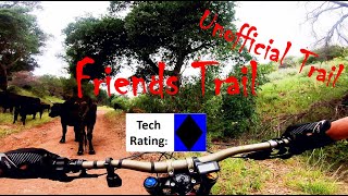
“A wide up or down path through a burned area from the Thomas Fire that is coming back to life. ”


2.0
Miles3.3
KMDoubletrack
 Intermediate
Land Manager: Ojai Valley Land Conservancy
 Ventura River Preserve Lollipop
10.0 mi 16.2 km • 1,280' Up 390.14 m Up • 1,280' Down 390.17 m Down

 Ventura River Preserve Loops around Wills Canyon
12.8 mi 20.6 km • 1,493' Up 455.13 m Up • 1,493' Down 455.11 m Down
 Harmon Loop
5.2 mi 8.4 km • 1,047' Up 319.04 m Up • 1,022' Down 311.65 m Down
Saticoy, CA
Cold Springs Loop
13.6 mi 21.9 km • 3,072' Up 936.47 m Up • 3,076' Down 937.48 m Down
Montecito, CA
 SB Front Country Loop
16.9 mi 27.2 km • 2,797' Up 852.47 m Up • 2,802' Down 853.93 m Down
Mission…, CA
Jesusita Out and Back
6.8 mi 10.9 km • 1,323' Up 403.18 m Up • 1,323' Down 403.19 m Down


0 Comments