
 Continue with onX Maps
 Continue with Facebook


 Difficult


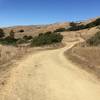
“Gunshot connects Brown Bridge (top of White Hill) to Loma Alta (Smith Ridge) with a brutal climb! ”


0.8
Miles1.2
KMDoubletrack
 Difficult
Local Club: Marin County Bicycle Coalition
Land Manager: Marin Municipal Water District
 Fairfax-Bo Ridge Gravel Grinder
43.0 mi 69.3 km • 3,369' Up 1026.92 m Up • 3,369' Down 1026.82 m Down
Fairfax, CA
Lucas Valley Loop
14.9 mi 23.9 km • 2,977' Up 907.35 m Up • 2,975' Down 906.7 m Down
 Mt Tam Summit Loop
16.3 mi 26.2 km • 2,450' Up 746.76 m Up • 2,448' Down 746.3 m Down
Tennessee Valley to Horseshoe Bay
8.6 mi 13.8 km • 1,145' Up 348.94 m Up • 1,343' Down 409.2 m Down
Golden Gate to Tennessee Beach Loop
17.9 mi 28.9 km • 2,443' Up 744.76 m Up • 2,477' Down 755.02 m Down
Sausalito, CA
Havey Trail Loop
5.2 mi 8.3 km • 1,044' Up 318.24 m Up • 1,050' Down 319.93 m Down


0 Comments