
 Continue with onX Maps
 Continue with Facebook


 Intermediate

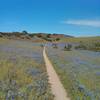
“A sandy start and a sandy finish with a good ridge ride along the way. ”


0.8
Miles1.3
KMSingletrack
 Intermediate
Local Club: Monterey Off Road Cycling Association
Land Manager: BLM California - Hollister Field Office
 Inter-Garrison Rd to Kyle's Bench loop.
8.7 mi 14.0 km • 468' Up 142.59 m Up • 486' Down 148.13 m Down


 Best of Ord - Short
17.9 mi 28.8 km • 2,176' Up 663.12 m Up • 2,177' Down 663.56 m Down
Salinas, CA
 Pipeline Loop
9.3 mi 14.9 km • 1,616' Up 492.63 m Up • 1,616' Down 492.47 m Down
Salinas, CA
EMT, U-Con, Chinquapin, Pipeline
11.7 mi 18.8 km • 1,199' Up 365.55 m Up • 1,199' Down 365.48 m Down
Santa Cruz, CA
Circle Loop
18.5 mi 29.8 km • 1,259' Up 383.63 m Up • 1,269' Down 386.67 m Down
Santa Cruz, CA
 Best of Wilder Ranch
16.6 mi 26.7 km • 1,371' Up 417.87 m Up • 1,361' Down 414.73 m Down


0 Comments