Dogs Unknown

E-Bikes
Unknown
Overview
This is a very nice rolling ride through Coast Live Oaks and Manzanita with some great views along the way. Views include Toro Mountain, Fremont Peak, the Santa Lucia Range, an overlook of "Impossible City" and a view of Monterey Bay toward Moss Landing.
There are many trails here not included on this route. A full map by the Bureau of Land Management is available at:
http://www.morcamtb.org/trails/fortordtrailmap0712.pdf.
Need to Know
These are multi use trails with dog walkers (possibly off leash), hikers, trail runners and equestrians.
There are currently lots of "No Trespassing" signs along the initial trail segment between Inter-Garrison and Giggling Rd. Don't worry, the area is legal but you are subject to a ticket if you stray. There is also plentiful poison oak and ticks in season so a cool shower after your ride is recommended.
Description
This fun ride starts from the parking area up a slight hill with some old pavement and Coast Live Oak on both sides. It opens to a field on the other side and then the Oaks close in a bit. You'll go until pavement and after you cross Watkins Gate Rd enter the Fort Ord National Monument. There is a vernal pool on the right.
Take a left on trail 14 up a gradual climb through the oaks until you reach Addington Rd. Turn right and look for a singletrack to the right (trail 20). This winds through grass and oaks with a slight climb. Look for trail 23 on your left. Take trail 23 which starts with a gradual climb and then has a short steep climb. There is plenty of poison oak along this trail so don't stray.
After a bit you'll cross a gravel road. 23 continues on the other side and transitions to manzanita. This is a bit tight depending on when it was trimmed last and has a fairly steep bit with a short climb on the other side. Watch out, there is a fence at the end of the trail that you have to go around to your left to exit out onto trail 15.
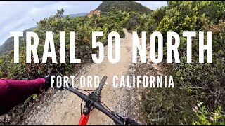
Head up the hill on trail 15 and look for trail 57 (after trail 16). If you look to your left you might see the old ammunition bunkers.
Trail 57 winds through the manzanita a bit more and takes you across Addington Rd again. Cross the road and continue. You'll have another vernal pool on your left. Continue on until you merge with trail 16. Continue on trail 16 up a hill until you reach trail 56.
Take a left on 56 and you'll gradually climb up toward Machine Gun Flats Rd (so named for the nearby machine gun range from the old Army Training days). The trail gets tight and tunnel-like with oaks and large manzanita. It is sometimes called the ghost trail.
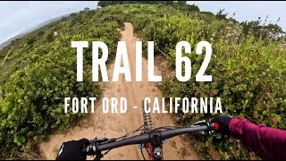
Take a left on Machine Gun Flats Rd. Notice that on your left are Coast Live Oak and on your right is Manzanita. You are on the edge of a transition. Keep a lookout on your right for trail 62 (it is easy to miss though there is a sign). Trail 62 is also called Chain Gang trail in honor of the prison work release crew that brushed this trail (and maybe also because of how windy the trail is like a chain thrown on the ground). After winding through the manzanita you'll get to where there is a nice view to your left and exit the trail over a large culvert.
Bear right up the hill onto trail 61. As you crest the hill look to your left for "Kyle's bench" (in honor of a young mountain biker that used to enjoy riding these trails). Ride out to the bench and enjoy the view. You should see Toro Mountain off in the distance.
Head back to trail 61 and continue to your left. You'll wind through the manzanita along the bluff come out on a paved road. Cross the road and right up Little Moab Rd. After a bit of a climb 96 goes off to your left. Follow this trail for a nice view of "Impossible City" an old Army "Military Operations in Urban Terrain" (MOUT) training site that is still used today by a variety of agencies including local law enforcement. The trail links back up to Little Moab Rd which you'll take to the right and up to the top of the hill. You can get a nice view from here on a clear day.
Head down the hill on trail 94 to Machine Gun Flats Rd and take a left. Go straight on trail 67 when the road turns left and look for trail 68 to the right. Drop down 68 (watch out for the barrier at the end of the trail) and take a left on the pavement. Watch out for 59 trail to your left. Known as "Blair Witch," this trail winds through manzanita and oak (and poison oak) to trail 69. Take a right on 69 and you'll wind through the oaks on an IMBA trail care crew project. Drop out onto Henneken Ranch Rd and go straight across to trail 14. Look for Comanche's grave on your right (the burial site of the last cavalry horse from Fort Ord).
Stay to your left and you'll come out of the Fort Ord National Monument, cross Watkin's Gate Road and head out the
Jerry Smith Corridor back to your car.
History & Background
These trails are on the former Fort Ord Army base closed in 1994 as part of the Base Realignment and Closure (BRAC) efforts of the day. After nearly 20 years, transition to other uses is still on going but much of the lands have been set aside for habitat conservation and non motorized recreation. For more information go to:
http://www.blm.gov/ca/st/en/fo/hollister/cultural/lightfighters.html.
Contacts
Shared By:
Darius Rike

 Continue with onX Maps
 Sign in with Facebook


 Easy/Intermediate

 Best of Ord - Short

 Salinas, CA
 Wilder Ranch Singletrack Loops


 All Clear


2 Comments