
 Continue with onX Maps
 Continue with Facebook


 Difficult

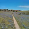
“Ridge trail with some great views of Salinas Valley, some steep rutted sections and a sandy exit. ”


0.8
Miles1.2
KMSingletrack
 Difficult
Local Club: Monterey Off Road Cycling Association
Land Manager: BLM California - Hollister Field Office
 Best of Ord - Short
17.9 mi 28.8 km • 2,176' Up 663.12 m Up • 2,177' Down 663.56 m Down

 Salinas, CA
Creekside Ride to Outhouse and back via Goat.
Salinas, CA
Creekside Ride to Outhouse and back via Goat.
12.9 mi 20.8 km • 1,444' Up 440.04 m Up • 1,432' Down 436.57 m Down
Salinas, CA
 2020 Sea Otter Cross Country - Category 1
29.4 mi 47.4 km • 3,419' Up 1042.14 m Up • 3,412' Down 1039.86 m Down
Del Rey…, CA
Couch Canyon
4.8 mi 7.7 km • 733' Up 223.41 m Up • 732' Down 223.18 m Down
Road Runner to Razorback
5.2 mi 8.4 km • 702' Up 213.88 m Up • 702' Down 214.09 m Down
Best of Nisene
18.6 mi 30.0 km • 1,951' Up 594.76 m Up • 1,945' Down 592.72 m Down


1 Comment