
 Continue with onX Maps
 Continue with Facebook


 Difficult

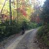
“A rough, rocky trail descending along Long Arm Branch. ”


4.1
Miles6.6
KMSingletrack
 Difficult
Local Club: SORBA - Tri-Cities
Land Manager: USFS - Cherokee National Forest - Nolichuky-Unaka Ranger Station
 Horse Creek Loop
6.8 mi 11.0 km • 1,045' Up 318.62 m Up • 1,045' Down 318.57 m Down

 Greene Mountain Loop
10.8 mi 17.4 km • 1,710' Up 521.31 m Up • 1,617' Down 492.96 m Down
 Buffalo Mountain Fire Tower
13.5 mi 21.7 km • 1,944' Up 592.49 m Up • 1,876' Down 571.75 m Down
ETSU XC Trail Lap
5.8 mi 9.3 km • 675' Up 205.62 m Up • 666' Down 203 m Down
The Full Buffalo
37.3 mi 60.1 km • 3,560' Up 1085.18 m Up • 3,561' Down 1085.26 m Down
Chestnut Flats Loops
15.0 mi 24.1 km • 2,971' Up 905.41 m Up • 2,970' Down 905.37 m Down


0 Comments