Dogs Unknown

E-Bikes
Not Allowed
Overview
Big climbs, big downhills, and gorgeous scenery! This is an advanced-intermediate tour of the western side of Dupont State Forest. It covers about 20 miles with 2100+ feet of elevation change.
Description
This route covers most of the west side of Dupont (park at Corn Mill Shoals parking lot). If short on time, you can skip the second loop to
Reasonover Creek and just do the three western-most loops. The entire route consists of four main loops.
Loop 1 is a clockwise loop of
Burnt Mountain. This is a great warmup loop with a steep but relatively short climb followed by some fun downhill. Good mix of flowy and technical terrain.
Loop 2 has a RIVER CROSSING at the beginning and end. (You'll have to cross the river twice so be prepared to get wet. If short on time or if you simply don't want to cross a river, you can skip this loop and move onto loop 3.) Loop 2 takes you east and covers
Laurel Ridge,
Mine Mountain,
Reasonover Creek,
Airstrip Trail, and then brings you back to
Corn Mill Shoals Trail. This loop has a great mix of terrain and will bring you by Lake Julia (great spot to take a break down by the water) and includes a great downhill at
Airstrip Trail.
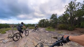
Loop 3 is the most challenging and has the most climbing. It will take you up
Cedar Rock to
Big Rock and back down. You'll be climbing mostly rock on the way up with some water flowing in some spots. At the top you'll see nice views from
Big Rock and then have a really fun and rocky downhill back towards the parking area. At this point you can decide whether you have enough left for Loop 4 or if you should just head back to your car.
Loop 4 is a great cool down loop. Rather than head back to the parking lot, you hang a right on
Longside which will take you through some fun terrain and connect you to Pine Tree and Cascade. This loop is a great change of pace (and scenery) from
Big Rock and a nice way to end your ride.
Contacts
Shared By:
Adam Knochowski
with improvements
by Mimi Mouse

 Continue with onX Maps
 Sign in with Facebook


 Difficult


 All Clear


5 Comments