Oct 29, 2023
Private User
Apr 11, 2023
Bennett Bennett
Rodé w andy one day gab and moreno crew next day and gab son Danny took
Jul 22, 2022
Private User
Apr 10, 2022
Kellog K
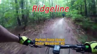
Rode Ridgeline and a loop towards the start of ridgeline. Super fun fast flow technical trail. I enjoyed my time in Dupont. lots more to do. parkin…
8.5mi
Feb 20, 2022
Russ Gowan
cool dry mostly and a new bike! what more could you ask for...
8.9mi
—
2h 25m
Aug 22, 2021
Bennett Bennett
Adam and josh we hiked through the woods got lost trying to cut off the gravel road sectio
Jul 1, 2021
Chris Rock
This trail is insane amounts of fun for someone who has been biking for about 4 months!
6.3mi
—
4h 00m
Jun 28, 2021
Dennis Tracey
Radically FUN!!! F$&@ YES!!! Woot WOOT!
Nov 28, 2020
Jason Martin
First time in DuPont with 7 year old sons and rode all but the rock garden at Jim Branch on 24" wheels. They loved the downhills, worked the climbs.
8.8mi
—
1h 25m
Jul 3, 2020
Ja Ka
Downhill at end was legit.
Jun 14, 2020
Sarah Doss
Lake Imaging parking lot. Lake imaging to Jim Branch to Buck Forest rd to White Pine to Hooker creek to Hickory Mtn (start right) to ridgeline
6.3mi
—
1h 45m
Sep 2, 2019
Charlie Scharfen
Geeen sections are mostly fire road which was a little annoying but the last section of downhill (ridgeline) is totally worth it
6.3mi
Aug 7, 2019
Bryan Glover
The whole north side of Dupont is just about perfect as of this morning.. Could use a light rain this afternoon to stay great for tomorrow
21mi
—
1h 57m
Jun 22, 2019
Larry Hughes
Ridgeline trail proper definitely worth the ride if you are in the area. The rest of the trails were fun, but ridgeline was the funnest!!
—
1h 50m
Jun 12, 2019
Bryan Glover
Trail in great shape after the rain
33.4mi
—
3h 07m
Jun 2, 2019
Eric Mowls
Locals mentioned that conditions where "sandy". I thought it was mostly a few loose grains on really nice hard pack. Nearly perfect on 2.1x29.
May 25, 2019
Todd Criswell
hooker falls and ridgeline with Patrick.
Apr 25, 2019
John Ghirardi
Did some variations that added to the length. The Jim Branch and Ridgeline sections are awesome. Bit too much fire road in the middle but recommended
10mi
—
1h 30m
Nov 24, 2018
Dave Campbell
Was wet today, but still a blast for my 1st time here.
6.2mi
—
1h 22m
Oct 27, 2018
Remmy Piper
first real mountain ride
1.7mi
Sep 1, 2018
Mason M
a nice easy one with a fun descent at the end!
Aug 14, 2018
C 2
Flow fo days!
Aug 4, 2018
Zandr Tesolowski
Saw two black bear on the trail at separate locations around 7:30am.
Jul 5, 2018
Dan Peterson
Fun ride with Ana. First time at Dupont State Forest.
Jun 24, 2018
Shawn Grogan
Jim branch to buck forest to white pine to hooker Creek to Ridgeline downhill!!!!
6.5mi
May 12, 2018
Cory Liverman
Love this trail. Flow....flow....flow! Just fun. Nothing here to kill you.
6.3mi
—
1h 30m
Apr 14, 2018
Nicholas Feliciano
This was a fun fast downhill. There was alot of people so had to slow down and stop a few time for the slow bikers ^_^
Dec 2, 2017
Edward Gurley
Such a fun, fast and flowy ride...speed demons paradise!
12.4mi
Oct 27, 2017
Bennett Bennett
Lily and I Mynorco range fucked up I don't like this bike it's front pronounced it is not good for climbing Lily loved this trail hated other one
Oct 15, 2017
Matt Sieber
Rode 2-3 times w/ a couple of different climbs on this route during Pisgah Mtn Bike Fest. Super fast and flowing...everybody loved it
Aug 25, 2017
Kent Harvey
CO rider / 1st ride in NC. Fantastic ride. Highly recommended.
Jun 28, 2017
Brendon Ritz
Top trail I have ridden. Great flow. Sis on 27 Jan at 1100. Perfect weather.
Jun 14, 2017
Todd Shafer
First time riding this trail great fun
6.2mi

 Continue with onX Maps
 Sign in with Facebook


 Intermediate

 4.7 (226)


 All Clear


13 Comments