This route includes some of the best DuPont has to offer from a flowy perspective, but you'll have to work at it with the climbs throughout the route.
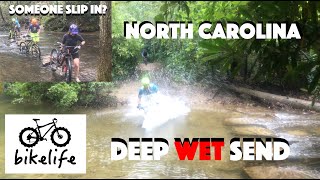
There are three creek crossings in this route, but in most cases, there are rocks that allow you to hop across without getting soaked.
There's two options for starting this ride, with Option 1 being what the GPS uses. Arguably, Option 2 adds a little more singletrack and removes the climb up
Lake Imaging Road.
Option 1: (The way the route was recorded and if you're following GPS, the way it'll take you.)
This route starts with a nice warm-up climb up Lake Imaging road. Take a right on to
Hilltop Loop.
Option 2: (And arguably a bit more fun and interesting)
Start out on
Lake Imaging Road going around the pond to the right. The first trail entrance to the left is
Jim Branch. Take a left on
Jim Branch. You'll have the option of bypassing the tough rock garden in favor of smoother singletrack if you wish.
Jim Branch is a 1.2 mile trail, which will be a climb in this direction. At the top of
Jim Branch, take a right on Issac Heath. Issac Heath is only .5 miles long and will lead you onto
Locust Trail. Take a right at the end of
Locust Trail where you'll immediately pick up
Hilltop Loop directly straight in front of you.
---- same from here ----
Hilltop Loop is a fun little loop that will spit you back out on Lake Imaging Rd. A short ride on Buck Forest Rd to Conservation Rd, and you'll take
Three Lakes Trail. At the end of this you're back on Conservation Rd where you'll climb a pretty steep road up to the Airstrip. Cross over the Airstrip, take Fawn Lake Rd over to
Mine Mountain Trail. The start of
Mine Mountain will be climbing, but the descent down to Fawn Lake parking area is a blast. You'll pass Fawn Lake parking lot on Fawn Lake Rd down to Conservation Rd. Cross over Conservation Rd to
Reasonover Creek Trail. At the bottom of this, you'll have to cross your first creek.
The next 2.5m is a climb up
Reasonover Creek to
Turkey Knob Rd & following
Turkey Knob Rd over to
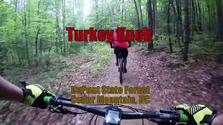
Turkey Knob Trail (newer trail).
Turkey Knob Trail is IMO the best trail of this loop.
The end of
Turkey Knob will dump you out at
Briery Fork trail where you'll find your second creek crossing and climb out for a while crossing over Joanna Rd to
Grassy Creek Trail.
A bit more climbing through
Wintergreen Falls and Tarklin Branch up to Guion Farm parking area, go into the parking area and out onto Hickory Mountain Rd. From Hickory Mountain Rd, you'll take a left on
Hooker Creek Trail, which is a super fast section, but can be dangerous if there are loose rocks on the trail. At the end of
Hooker Creek, you'll cross your third and final creek crossing. After the crossing, you'll climb back out to
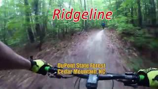
Ridgeline Trail.
Ridgeline probably doesn't need an introduction, but this is a super fast downhill that will finish your ride.
If you'd like to add some length to this already burly ride, add The Best of Dupont:
Burnt Mountain/
Cedar Rock Big Rock Figure 8 to your outing.
Here is turn by turn directions with distances:
Start from Lake Imaging Parking Lot (distance in miles)
Option 1:
- Start on Lake Imaging Rd (1.0)
- Right on
Hilltop Loop (1.0)
Option 2:
- Start on Lake Imaging Rd (0.4)
- Left on
Jim Branch (1.2)
- Right on Issac Heath (0.5)
- Right (more straight than anything) on
Locust Trail (0.4)
- Right on Lake Imaging Rd and immediately onto
Hilltop Loop (1.0)
---- end options. Same from here on out ----
- Right on Lake Imaging Rd (0.1)
- Right on Buck Forest Rd (0.5)
- Left on Conservation Rd (0.1)
- Left on
Three Lakes Trail (1.7)
- Left on Conservation Rd climb road up to Airstrip [avoid Shortcut Trail] (1.0)
- Right on Fawn Lake Rd (0.1)
- Right on
Mine Mountain Trail (1.4)
- Right on Fawn Lake Rd (0.2)
- Cross over Conservation Rd to
Reasonover Creek Trail (1.2)
- Right on
Turkey Knob Trail (3.3)
- Right on
Briery Fork trail (0.4)
- Cross over Joanna Rd to
Grassy Creek Trail (1.5)
- Right on Sandy Trail (0.1)
- Left on
Wintergreen Falls Trail (0.4)
- Right on Tarklin Branch Rd (0.8)
- Left on Guion Farm
Connector (0.4)
- Cross over Buck Forest Rd to Hickory Mountain Rd (0.3)
- Follow Hickory Mountain Rd to the top of
Ridgeline
or
- Left on White Pine Trail (0.2)
- Rt on
Hooker Creek
- Left on
Ridgeline

 Continue with onX Maps
 Sign in with Facebook


 Intermediate/Difficult

 4.6 (217)


 Minor Issues


40 Comments