
 Continue with onX Maps
 Sign in with Facebook


 Difficult

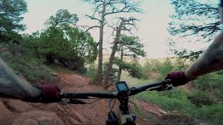
“A technical connecter between Lion Trail and Hogback Ridge Trail. ”


0.4
Miles0.6
KMSingletrack
 Difficult
Local Club: Medicine Wheel Trail Advocates
Land Manager: City of Colorado Springs, CO- Parks, Trails & Open Space
 Roundup Trail Loop at Red Rock Canyon Open Space
3.5 mi 5.7 km • 432' Up 131.55 m Up • 439' Down 133.83 m Down

 Lung Buster to Wrist Thrasher
11.2 mi 18.1 km • 1,856' Up 565.71 m Up • 1,856' Down 565.66 m Down
 Manitou…, CO
Red Rock Canyon Tour
Manitou…, CO
Red Rock Canyon Tour
7.5 mi 12.1 km • 861' Up 262.45 m Up • 859' Down 261.79 m Down
D-Loop #3
16.4 mi 26.4 km • 2,892' Up 881.61 m Up • 2,899' Down 883.6 m Down
D-Loop #8B - Stratton
5.7 mi 9.2 km • 806' Up 245.59 m Up • 809' Down 246.62 m Down
Colorad…, CO
 Canyon Climbfest
25.5 mi 41.1 km • 3,619' Up 1102.94 m Up • 3,650' Down 1112.37 m Down


 All Clear


0 Comments