
 Continue with onX Maps
 Sign in with Facebook


 Easy
Easy

“A scenic paved bike trail connecting Thunder Mountain and Coyote Hollow to create a loop. ”


8.9
Miles14.2
KMPaved Path
 Easy
Easy
Local Club: Trail Alliance of Southern Utah (TASU)
Land Manager: USFS - Dixie National Forest Office
 Thunder Mountain Loop
15.9 mi 25.7 km • 1,627' Up 495.91 m Up • 1,633' Down 497.66 m Down

 Panguitch, UT
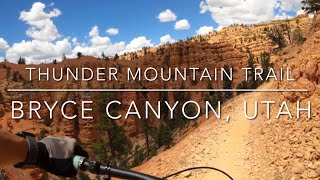
Thunder Mountain Trail
Panguitch, UT
Thunder Mountain Trail
8.1 mi 13.1 km • 689' Up 210.11 m Up • 1,681' Down 512.29 m Down
Panguitch, UT
 Kodachrome Basin Full Loop
5.8 mi 9.3 km • 377' Up 115.02 m Up • 377' Down 114.96 m Down
 Navajo Lake and Virgin River Rim
13.8 mi 22.2 km • 1,132' Up 344.97 m Up • 1,128' Down 343.78 m Down
White's Loop
3.6 mi 5.8 km • 691' Up 210.52 m Up • 691' Down 210.74 m Down
Navajo Lake Loop
11.2 mi 18.0 km • 635' Up 193.65 m Up • 635' Down 193.57 m Down
")


1 Comment