
 Continue with onX Maps
 Continue with Facebook


 Intermediate


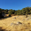
“A roller coaster, ridge-top fire road with great views and fast descents. ”


2.7
Miles4.4
KMDoubletrack


0 Comments