
 Continue with onX Maps
 Sign in with Facebook


 Intermediate/Difficult

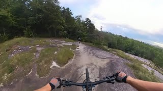
“A mix of technical, rocky sections and fast, flowy singletrack. ”


3.8
Miles6.1
KMSingletrack
 Intermediate/Difficult
Local Club: Pisgah Area SORBA
Land Manager: North Carolina Forest Service - Dupont State Forest
 Lake Imaging Lollipop
14.0 mi 22.6 km • 1,454' Up 443.09 m Up • 1,452' Down 442.67 m Down

 Brevard, NC
 Lake Imaging Loop
9.5 mi 15.2 km • 1,061' Up 323.47 m Up • 1,062' Down 323.63 m Down
Brevard, NC
Quick Ridgeline Route
4.9 mi 7.9 km • 582' Up 177.25 m Up • 583' Down 177.8 m Down
Brevard, NC
DuPont Ridgeline
6.3 mi 10.1 km • 697' Up 212.55 m Up • 694' Down 211.63 m Down
Brevard, NC
Pisgah 111K
72.1 mi 116.0 km • 8,909' Up 2715.32 m Up • 8,903' Down 2713.64 m Down
Brevard, NC
 Pisgah Stage Race - Stage 3
31.4 mi 50.5 km • 5,727' Up 1745.44 m Up • 5,728' Down 1745.87 m Down
Brevard, NC


0 Comments