Dogs Off-leash

E-Bikes
Unknown
Overview
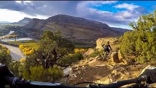
Exposure on-par with Moab's Porcupine Rim, but with fewer people and more singletrack.
Need to Know
Bring plenty of water. Avoid the upper loop after rain. Watch where you are going, falling in some spots could be fatal. Stop by the Palisade Brewing Company for a pint after your ride. Visit Rapid Creek Cycles in Palisade for current trail conditions.
Description
Park at the river launch site approx 200 yards north of the trailhead. The trail begins next to a large gate, start the climb up and around the irrigation ditch.
The initial 800 foot climb has just enough switchbacks to keep you on the bike, with plenty of short technical challenges to keep your attention.
At the top of the first climb, catch your breath and enjoy the view of Colorado's Wine Country. If you plan on doing both loops you have another 700 feet of climbing ahead of you, but it comes over more miles than the first climb.
Back on the bike, keep heading uphill and take a left at the intersection (trail is great in both directions, but flows better this way). Crank another mile over varied terrain to the upper loop connector trail. Take a left here to access the challenging upper loop, or stay right if you only want the lower action. Look off to the right and admire the petroglyphs on the sandstone (look, don't touch please).
Charge up the connector trail for 0.8 miles to reach the upper loop, and again go left at the intersection. This 4 mile loop has it all: rocks, dirt, shale, berms, twists, short climbs and plenty of cliff exposure. The highlight for most riders will probably be hammering down the west side of the upper loop, don't let the exposure rattle your nerves.
Head down the connector trail and rejoin the lower loop near the petroglyphs. The second half of the lower loop offers more rocky challenges, but with less exposure than the upper loop.
Now lower your seat a few inches and prepare to drop 800 feet back down to the parking lot (control your speed and watch out for hikers and shear cliffs).
History & Background
Contacts
Shared By:
Andrew Judkins

 Continue with onX Maps
 Sign in with Facebook


 Difficult

 4.2 (103)


 All Clear


4 Comments