
 Continue with onX Maps
 Continue with Facebook


 Difficult

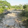
“A rocky singletrack follows the fence line of Perdernales Falls State Park. ”


0.9
Miles1.5
KMSingletrack
 Difficult
Land Manager: Texas Parks and Wildlife Department (TPWD)
 Great Beginner-Intermediate Route
10.1 mi 16.2 km • 468' Up 142.51 m Up • 444' Down 135.22 m Down
 Lakeway Greenbelt and City Park Tour
11.7 mi 18.9 km • 718' Up 218.71 m Up • 719' Down 219.09 m Down
 The Great Escape Loop
6.3 mi 10.2 km • 333' Up 101.39 m Up • 329' Down 100.25 m Down
Slaughter Creek Trail
5.4 mi 8.7 km • 208' Up 63.4 m Up • 212' Down 64.55 m Down
 Madrone Trail
7.6 mi 12.2 km • 557' Up 169.81 m Up • 529' Down 161.15 m Down
 Emma Long Motocross Park: Main Loop
5.7 mi 9.1 km • 529' Up 161.09 m Up • 529' Down 161.13 m Down
Lost Creek, TX


0 Comments