This is the next section north from
BCT: New River to Table Mesa Trailhead, consisting of six named segments from south to north:
Table Mesa Segment 1.5 mi
Little Pan Segment 3.2 mi
Williams Mesa Segment 3.1 mi
Cheapshot Segment 3.4 mi
Skyline Segment 3.1 mi
Horseshoe Segment 1.5 mi
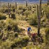
This section is much more technical than those to the south, such as
BCT: New River to Table Mesa Trailhead. From Table Mesa to Black Canyon, out and back is 24 miles. I chose to ride from Table Mesa to the end of Cheapshot and back, which was 16 miles and 2,600 feet of ascending, taking
Little Pan north and the west option south.
Next, I rode from Black Canyon to Cheapshot, which was 12 miles and 1,600 feet of ascent. This was a nice way to split up the section. The description below takes the perspective of a single ride, from the south.
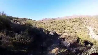
Leaving Table Mesa and dropping to the Agua Fria River, the trail runs along ledges with steep cross slopes. This is a good warmup and preview. If you don’t enjoy this bit of exposure, then what’s ahead will not be fun.
Crossing the normally dry river bed, the trail climbs to a split. Here you get to choose from
Little Pan Segment to the east or the west trail.
Little Pan includes about 0.7 miles of road, while the west option is all primo singletrack that rolls through small washes and traverses narrow ledges.
If you take the
Little Pan option to the east, at 3.7 miles from Table Mesa, you'll descend towards a large cliff and reach another crossing of the Agua Fria. The trail formerly crossed the river near the cliff, but after extensive erosion, it now goes upstream a couple hundred feet.
In December 2018, there was water at this point in the river. I was able to cross by stepping on rocks and using the bike for balance. The trail goes downstream a short distance then climbs up a bedrock slope to the north.
From here, the trail crosses a wash and goes between some yellow posts to join a road. There is another unknown trail that bears off to the left, but stay on the road.
Grind up the road past T9985, which leads to the “Indian Fort”, before rejoining the west branch at a saddle.

 Continue with onX Maps
 Continue with Facebook


 Difficult


0 Comments