
 Continue with onX Maps
 Continue with Facebook


 Easy/Intermediate

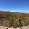
“A short fire road that connects to the end of Reasonover Creek and offers some nice views across Summit Lake. ”


0.4
Miles0.7
KMDoubletrack
 Easy/Intermediate
Local Club: Pisgah Area SORBA
Land Manager: North Carolina Forest Service - Dupont State Forest
 The Best of Dupont: Burnt Mtn. / Cedar Rock Big Rock Figure-Eight
6.3 mi 10.1 km • 773' Up 235.55 m Up • 772' Down 235.17 m Down

 Brevard, NC
 Quick Ridgeline Route
4.9 mi 7.9 km • 582' Up 177.25 m Up • 583' Down 177.8 m Down
Brevard, NC
Pisgah Stage Race - Stage 5
28.5 mi 45.8 km • 2,863' Up 872.78 m Up • 2,780' Down 847.39 m Down
Brevard, NC
Pisgah Stage Race - Stage 3
31.4 mi 50.5 km • 5,727' Up 1745.44 m Up • 5,728' Down 1745.87 m Down
Brevard, NC
Avery Creek to Bennett Gap Loop
15.7 mi 25.2 km • 3,013' Up 918.33 m Up • 3,017' Down 919.45 m Down
Brevard, NC
Bennett Gap Loop
6.6 mi 10.6 km • 1,299' Up 395.93 m Up • 1,303' Down 397.12 m Down
Brevard, NC


0 Comments