Dogs Unknown

Need to Know
The trail was re-routed recently for the opening of Rancho San Vicente, and most older maps do not show the trail in the correct place (the old trail's lower entrance at Cottle Rest Site is marked "Keep off", and the original, much steeper route has been consciously and thoroughly obliterated). The track on this trail was verified and is up-to-date.
This trail is very remote and there's no cell coverage in the area. Make sure you have all the required tools and expertise to fix common bike problems (flat tires, etc).
Description
Chisnantuk Peak
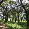
Trail is a 2.5 mile "wide singletrack" connecting Calero County Park and Rancho Cañada del Oro. To get there, start at the Rancho San Vicente entrance and take either
Lisa Killough Trail or
Cottle Trail. Ride until these trails meet again at their southern ends. Continue on
Cottle Trail going west. During the wet season, there are three small streams that will need to be crossed (nothing big, really, and they should be dry most of the year).
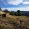
Cottle Trail becomes a somewhat steep fire road on its last half mile. Ride it up to the Cottle Rest Site, where Chisnantuk Peak
Trail starts.
Chisnantuk Peak
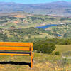
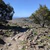
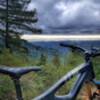
Trail climbs from Calero to Rancho Cañada del Oro at a more or less constant grade of 5%. This grade is sufficient to keep a good pedaling stroke while gaining some elevation. There are nice photo opportunities three-quarters of the way up.
At the trail's end, you'll reach
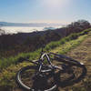
Bald Peaks Trail (bordering Rancho Cañada del Oro OSP). At this point, you have the option of riding back down (2.5 flowy miles of gentle downhill, with fun and smiles!) or continue up on Bald Peaks and make your way down to the main parking lot of Rancho Cañada del Oro.
Contacts
Shared By:
Marco Paganini
with improvements
by A B
and 1 other

 Continue with onX Maps
 Continue with Facebook


 Intermediate

 4.6 (24)


0 Comments