Dogs Leashed

E-Bikes
Unknown
Overview
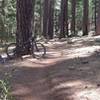
This is the most common loop around Lake Mendocino. The loop includes fun, rolling singletrack along the eastern and western portions of the lake as well as some short, paved connections (including one two-mile long highway stretch at the north end).
The loop is pretty straightforward and takes ~two hours for the average rider. There are fun opportunities at the southeast end to add small bonus loops and explore a little extra singletrack off the
Manzanita Trail.
Keep an eye out for equestrians; however, the area generally receives pretty low traffic.
Need to Know
This area gets pretty soggy after it rains, so be sure to give it plenty of time to dry out. Also, equestrians occasionally use the area, so be sure to ride with care and respect the resource.
Description
Start at the
Shakota Trail overlook off of Lake Mendocino Drive. From there, head north along the
Shakota Trail for approximately three miles before it meets up with Marina Drive and a campground at the northwest corner of the lake. Take Marina Drive out to Highway 20 and put your head down to get through two unpleasant miles of riding on the shoulder.
After two miles heading east on Highway 20, you'll see an off-ramp for Lake Mendocino on the north side of the road. Get off the highway here and ride the pavement through Bushay Campground. This will dead end at gate leading to an old fire road. Continue past the gate onto the fire road.
The
Eastside Trail singletrack will head along the entire eastern side of the lake, weaving back and forth over this road. Continue until you see a trail sign off to your right for the
Eastside Trail.
Continue on south along the rolling singletrack. You'll cross over the fire road a few times and past a boat-in campground. Shortly after the boat-in campground, you'll hit a creek crossing near the southeast edge of the lake (you'll be getting your feet wet if it's winter time).
Continue along the singletrack and stay to the right keeping an eye out for signs for the
Manzanita Trail. Stay on this for a couple miles past a large spillway until you reach Coyote Dam. From here, cross the dam and take the short road climb back to the
Shakota Trail overlook.
Contacts
Shared By:
Simon Topp

 Continue with onX Maps
 Continue with Facebook


 Intermediate/Difficult


0 Comments