
 Continue with onX Maps
 Continue with Facebook


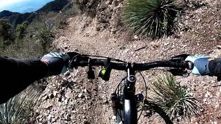
“A high-elevation singletrack with views! ”


1.6
Miles2.6
KMSingletrack

Land Manager: USFS - Angeles National Forest Office
 Mt. Wilson Shuttle
6.9 mi 11.1 km • 193' Up 58.73 m Up • 4,876' Down 1486.28 m Down

 Sunset Ridge / El Prieto Loop from Millard Campground
14.3 mi 23.1 km • 2,914' Up 888.07 m Up • 2,941' Down 896.39 m Down
 Altadena, CA
 Lukens/Grizzly Flat/Hoyt Mtn Loop
11.4 mi 18.3 km • 1,964' Up 598.57 m Up • 1,966' Down 599.29 m Down
Super Strawberry
25.5 mi 41.1 km • 2,639' Up 804.51 m Up • 5,130' Down 1563.76 m Down
Altadena, CA
Glendale Sports Complex - Cherry Canyon Loop
8.8 mi 14.2 km • 1,381' Up 420.81 m Up • 1,380' Down 420.61 m Down
La Caña…, CA
Hillyer - Silver Moccasin Loop
13.3 mi 21.4 km • 1,649' Up 502.69 m Up • 1,639' Down 499.43 m Down
Monrovia, CA


1 Comment