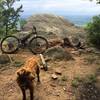
Dogs No Dogs

E-Bikes
Unknown
Overview
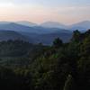
As the highest MTB trail system east of the Rockies, the Emerald Outback (EMO) claims a similar distinction as neighboring Beech Mountain Resort (BMR), which happens to be the highest lift-accessible bike park east of the Rockies. The landscape at this altitude is very unique; there are beech trees everywhere (as well as their roots), and also grassy lush green undergrowth and ferns. With scattered rocks and boulders and destination-quality views, this is one memorable place to ride. The systems seven singletrack trails are of varying difficulty, and all stay above 4500. With an additional network of grassy roads and other doubletrack accessible from the trailhead, there is something here to ride for everyone. This featured ride follows several of the intermediate and advanced-rated singletrack trails.
Need to Know
EMO trails are managed by the Town of Beech Mountain. The adjacent BMR mountain biking trails (lift accessible) are adjacent to these cross-country trails, and absolutely need to be considered on a trip up to Beech.
The weather on Beech Mountain changes constantly. It's a good idea to check with the town Parks and Recreation office at (828) 387-3003 for an update on the conditions at Beech.
There are two main parking lots, the Summit Lot, and the Base Lot. To access summit lot, turn left on N. Pinnacle Ridge Rd. from the Beech Mtn Parkway and follow the signs for EMO. The Base Lot is closest to the Visitors Center where there are Restrooms and a Bike Wash. This ride starts at the Base Lot and follows the cues below.
With the exception of
Southern Ridge, some of the trails in this featured ride are great the other direction. For more info or to piece together another loop, see the description and elevation profiles of the individual trails.
Description
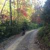
Starting at the Base Lot, ride across the parkway and up Summer Rd. Following the signs for Emerald Outback, you'll merge onto Oz Rd. and cross the ski slopes. The trails you see here are part of the BMR trail system and a pass is needed to ride them. After the ski slopes when you reach the car accessible part of Oz Road, bear right. Stay on the road. When you arrive at the Summit Lot, ride under the gateway and begin the singletrack with
Oz Forest Run. Like many of the trails at EMO, this trail has received a recent facelift and has been optimized for riding. There are several alternate lines on this trail with some fun rocky features.
After about a mile,
Oz Forest Run ends at
Southern Ridge Trail and
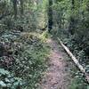
Wizard's Way. Turn Right on Wizards briefly and then take a left on Jackalopes Trail. Jackalopes is tight and twisty, and one of the more technical trails at EMO. Some of the trail segments here remain from the rake and ride days and also from a time when the NORBA XC race circuit stopped here in the 1990s. The trail crosses several small creeks and the headwaters of Buckeye Creek, including a nice waterfall called Zig-Zag Falls.
Take a right on
Northview a short, open trail that is one of the least technical at Beech. When you arrive at the intersection of
Southern Ridge and
Chamberlin's Loop, stay right. At the next intersection, youll see a sign for Chamberlins again. Take a right here.
Chamberlins is a lollipop design. This trail is the only trail that has not been re-worked as part of the recent trail efforts. Its very unique in that the trail is very narrow with lush undergrowth and large ferns. The end of Chamberlins is a good pitch. After completing the loop portion, youll stay right on all the intersections and turn right on
Southern Ridge.
Southern Ridge Trail is definitely worth the work as it offers amazing views of the Elk River Valley, Grandfather Mountain, and the BMRs Oz Run. Beyond the overlooks the trail will get steep, rocky and tight, so if you arent up for that, you can backtrack this route to the intersection of Chamberlins and take the
Grassy Rd 1 and Bail-Out Rd back.
When arriving back at the intersection of
Oz Forest Run there are two options. Oz can be taken to the right for a bit more mileage and a reverse of the first trail on this loop. The other option is left on the shorter
Wizard's Way, which this route follows.
Once you are back at the Summit Lot Gateway you can stop and relax or continue to backtrack the same roads from the start of the ride.
History & Background
EMO is possible due to the Town of Beech Mountain working with the adjacent landowner, Emerald Mountain, Inc. who has generously granted access through a land easement. Some of the trails have been around for a while and recently been re-worked through grant funding and oversight from Beech Mountain Parks and Recreation.
Contacts
Shared By:
Paul Stahlschmidt
with improvements
by TB Carolinian

 Continue with onX Maps
 Continue with Facebook


 Difficult

 Rocky Knob Park

 Boone, NC
 Watershed Trails
 Yelling and Dam Builder Loop


4 Comments