Dogs No Dogs

E-Bikes
Unknown

This is a popular route for hikers with some blind corners, some steep rocky sections, some off camber sharp turns. Keep your speed under control.
The road will get sandy and loose after it is graded in mid-summer. It holds up pretty well to rain and is often one of the first rideable trails when thinks start to dry out.
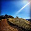
The trail is quite exposed to afternoon sun so climbing it on a warm afternoon can be challenging.
Description
Wall Point Rd is one of the most beautiful fire roads in the area. It has great close up views of Mt Diablo and Las Trampas and longer distance views of the Sacramento River delta, San Francisco and Mt Tamalpais.
While quite climbable, it is much more fun to descend (at least during the times of year when isn't full of loose dirt and sand). The trail starts near the parking and bathrooms at Lower Rock city on the northern side of South Gate Rd. The entrance is fairly obvious as it is a fire road with a large gate.
Wall Point Rd descends for about 3.5 miles with a few short climbs interspersed to slow you down. This is a popular route for hikers with some blind corners, some steep rocky sections, some off camber sharp turns. Keep your speed under control.
Maps vary on their naming of the last part of the trail but this description assumes that the Wall Point Road trail goes all the way to Macedo Ranch. At the end of the descent the fire road dead ends into another fire road. Turn left and go about 1/2 mile. Then turn left on a fire road that leads to the Macedo Ranch staging area.
Contacts
Shared By:
Mike Anciaux

 Continue with onX Maps
 Continue with Facebook


 Intermediate/Difficult


2 Comments