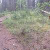
“Summer access road linking Hwy 66 and Hwy 68 ”
19.8
Miles31.9
KMDoubletrack

Land Manager: Alberta Parks
 Unknown
 Powderface Loop
12.8 mi 20.6 km • 2,016' Up 614.37 m Up • 2,025' Down 617.29 m Down


 Black D…, AB
 Moosepackers Loop
16.0 mi 25.8 km • 3,509' Up 1069.45 m Up • 3,508' Down 1069.31 m Down


 Calgary, AB
 Northern Flow
5.8 mi 9.3 km • 1,000' Up 304.79 m Up • 1,000' Down 304.74 m Down


 Calgary, AB
 Goldilocks Loop
6.1 mi 9.8 km • 1,181' Up 360.11 m Up • 1,180' Down 359.75 m Down


 Calgary, AB
 Prairie View - Jewell Pass Loop
9.4 mi 15.2 km • 1,838' Up 560.27 m Up • 1,838' Down 560.26 m Down


 Canmore, AB
 Grotto Mountain Trails Tour
8.2 mi 13.2 km • 1,504' Up 458.28 m Up • 1,519' Down 463.07 m Down


 Canmore, AB


0 Comments