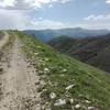
Biking trail description:
The biking trail is located in Gandzakar Village of the Tavush Province. There are several biking trails in Teghut and Haghartsin Villages and the
Ijevan Sierra that can be used during the riding too. This trail starts from Gandzakar, which has a 850 meter altitude from the sea level, and comes up to a 1780 meter altitude from the sea level. Then, it goes down, by the solid ground, passing through several villages of Tavush, and the final destination is Berd Town.
Monuments description:
Berd is a town in the Tavush Province that is situated on the bench of Tavush River. The origin of the name comes from the fortress of the city that is constructed in the 10th Century. It is surrounded by Tavush Sierra. The “must visit” places are Vagavank and Khoranashat Monasteries, constructed in the 12th Century, the Cyclopean Fortress, and the city museum. Also, it is suggested to visit Haghartsin Monastery in Haghartsin Village, Goshavank Monastery in Gosh village, Parz and Gosh Lakes in Dilijan National Park on the way.
Flora:
Half of the province is covered with forests. In some places, there are fruitful trees of pomegranate, peach, apricot, olive, lemon, etc, and wild trees of beech, oak, hornbeam, lime, and maple.
Fauna:
The province has rich fauna. In the forests, there are deer, Caucasian bears, wild pig, rabbits, foxes, panther, etc.
Trail technical parameters:
Best period: May-October
Distance: 138 km from Yerevan
Duration: 2 hours 14 min
Hiking trail length: 46.8 km
Ride duration: 5 hours
Altitude from the see level: 855-1861- 947m
Take bottled water with you.

 Continue with onX Maps
 Continue with Facebook


 Intermediate


0 Comments