
 Continue with onX Maps
 Continue with Facebook


 Intermediate

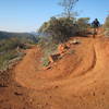
“An extension of the Olmsted Trail loop that travels to the edge of the American River Canyon. ”


2.5
Miles4.1
KMSingletrack
 Intermediate
Land Manager: Auburn State Recreation Area (ASRA)
 Salmon Falls (Darrington Trail)
15.9 mi 25.6 km • 717' Up 218.52 m Up • 717' Down 218.57 m Down

 Skunk Hollow to Magnolia Ranch
23.3 mi 37.4 km • 2,758' Up 840.79 m Up • 2,761' Down 841.65 m Down
 Skunk Hollow to South Fork ART (American River Trail)
14.1 mi 22.6 km • 1,693' Up 515.88 m Up • 1,697' Down 517.14 m Down
Foresthill Connector to Confluence
7.4 mi 11.9 km • 536' Up 163.47 m Up • 1,656' Down 504.62 m Down
 Auburn…, CA
El Dorado Trail - Placerville to Folsom
Auburn…, CA
El Dorado Trail - Placerville to Folsom
32.6 mi 52.5 km • 436' Up 132.91 m Up • 1,874' Down 571.15 m Down
 Lake Natoma Loop
12.0 mi 19.3 km • 294' Up 89.75 m Up • 294' Down 89.48 m Down


0 Comments