Dogs Leashed

E-Bikes
Unknown
Description
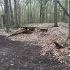
This loop section sits between the
Blue Trail and
Green Trail as part of the Andrews University Trail. From where it starts off of the
Green Trail, riders will head up a gravel road and turn left at the top of the hill to enter a short and rooted descent. Once in the bottom of the valley, you'll have a series of short downhills and quick turns, but overall this section mainly has long sustained climbs.
At one point, you'll emerge from the woods and find a fast descent over a man-made wooden plank bridge that immediately climbs up the other side after a sharp turn. This section will likely find beginner and immediate riders walking their bikes several times wondering how the advanced riders make it up and over the obstacles. In my opinion, this section is the most grueling and difficult part of the network.
Like the other outer loops, the Orange trail winds back to end very close to where it started.
Contacts
Shared By:
Wade Ritchie

 Continue with onX Maps
 Continue with Facebook


 Difficult


 All Clear


0 Comments