
 Continue with onX Maps
 Continue with Facebook


 Intermediate


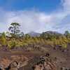
“A forest road on the north side of Tenerife. ”


3.4
Miles5.5
KMDoubletrack
 Intermediate
 BC-1 Ruta Forestal del Norte
54.2 mi 87.3 km • 6,919' Up 2108.84 m Up • 5,053' Down 1540.03 m Down
 Las Luganates
18.1 mi 29.1 km • 2,402' Up 732.25 m Up • 2,401' Down 731.82 m Down
Arenas Negras (Black Sands)
21.3 mi 34.2 km • 1,890' Up 576.04 m Up • 1,896' Down 577.83 m Down
Montañas Negras (Black Mountains)
27.7 mi 44.5 km • 3,679' Up 1121.48 m Up • 3,679' Down 1121.33 m Down
 Santiag…, ES


0 Comments