MTB Project Logo

An invigorating climb up into the big trees.


Your Rating: Rating Rating Rating Rating Rating      Clear Rating
Your Difficulty:
Your Favorites: Add To-Do · Your List
Zoom in to see details
Map Key

2.7

Miles

4.3

KM

Singletrack

7,770' 2,368 m

High

6,888' 2,099 m

Low

887' 270 m

Up

5' 2 m

Down

6%

Avg Grade (4°)

22%

Max Grade (12°)

Dogs Unknown

E-Bikes Unknown

Description

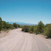
The trail runs up along an arroyo, crosses over, and then begins a series of steep climbs followed by a few flatter areas. It joins an old roadbed along the way, which angles steeply up the mountainside.

Vegetation increases from the start, and before you know it you are in the big trees. It is a dramatic shift from the "Pinon-Juniper belt" to the "Pine-oak belt."

The trail follows a canyon until it reaches Salazar tank. Coming back down is loose in spots, technical, and good riding.

This trail is a good workout, quite scenic and worth checking out.

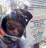
According to the USFS page, Salazar Trail "was once an access road used for uranium exploration by mining companies in the late 1960's and early 1970's."

Contacts

Shared By:

John Geronimo

Trail Ratings

  3.5 from 2 votes

#3

in Abiquiu

#21905

Overall
  3.5 from 2 votes
5 Star
0%
4 Star
50%
3 Star
50%
2 Star
0%
1 Star
0%
Trail Rankings

#3

in Abiquiu

#496

in New Mexico

#21,905

Overall
4 Views Last Month
694 Since Nov 4, 2016
Difficult Difficult

0%
0%
0%
0%
100%
0%

Photos

Old uranium road, looking down the valley towards Abiqui.
Nov 4, 2016 near Tierra…, NM
Chunky climb.
Nov 4, 2016 near Tierra…, NM
Canyon leading to Salazar Tank.
Nov 4, 2016 near Tierra…, NM
Heading west from the trailhead.
Nov 4, 2016 near Tierra…, NM
Plateau section.
Nov 4, 2016 near Tierra…, NM
Big trees.
Nov 4, 2016 near Tierra…, NM
loading

Weather


Current Trail Conditions

Unknown
Add Your Check-In

Check-Ins

none
Welcome

Join the Community

Create your FREE account today!
Already have an account? Login to close this notice.

Get Started